Subject: Asia
Period: 1710 (circa)
Publication: Atlas Novus
Color: Hand Color
Size:
13.9 x 9.1 inches
35.3 x 23.1 cm
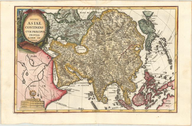
On this map of continental Asia and the adjacent islands, Japan is shown with an oversized Terra Iedso (Hokkaido) connected with Honshu via a narrow isthmus. The Compagnie Land of the de Vries expedition is shown above, separated by a narrow strait named after the explorer. Nova Zembla is depicted correctly as an island, but the northeastern part of Siberia, the Chukchi peninsula and Kamchatka are missing. A portion of Australia is shown as Nova Hollandia with New Guinea shown separate from Terra des Papous. The title is surrounded with a beautifully engraved cartouche, and the scale of miles is topped by the symbol for the Society of Jesus.
References: Shirley (BL Atlases) T.SHER-1a #153; Walter #116; Yeo #92.
Condition: A
A sharp impression on a clean, bright sheet with a hint of toning along the edges of the sheet and a faint damp stain in the top blank margin.