Subject: Arabia
Period: 1618 (published)
Publication: Theatrum Geographiae Veteris…
Color: Hand Color
Size:
18.9 x 13.2 inches
48 x 33.5 cm
Claudius Ptolemy was a mathematician, astronomer and geographer who worked in Alexandria, then a part of the Roman Empire, in the 2nd century AD. One of the most learned and influential men of his time, his theories dominated both astronomy and geography for nearly 1500 years. His writings were kept alive by Arabic scholars during the Middle Ages and reemerged in Europe during the Renaissance. The birth of printing led to wide dissemination of his great works on astronomy and geography. There were a number of editions of his Geographia beginning in 1477. These early editions contained maps based on his original writings, known as Ptolemaic maps. As geographic knowledge increased with the explorations of Columbus, Magellan, Cabot and others, maps of the New World were added, and maps of the Old World were revised. Ptolemy's Geographia continued to be revised and published by some of the most important cartographers including Martin Waldseemuller, Sebastian Munster, Giacomo Gastaldi, Jodocus Hondius, and Gerard Mercator (whose last edition was published in 1730).
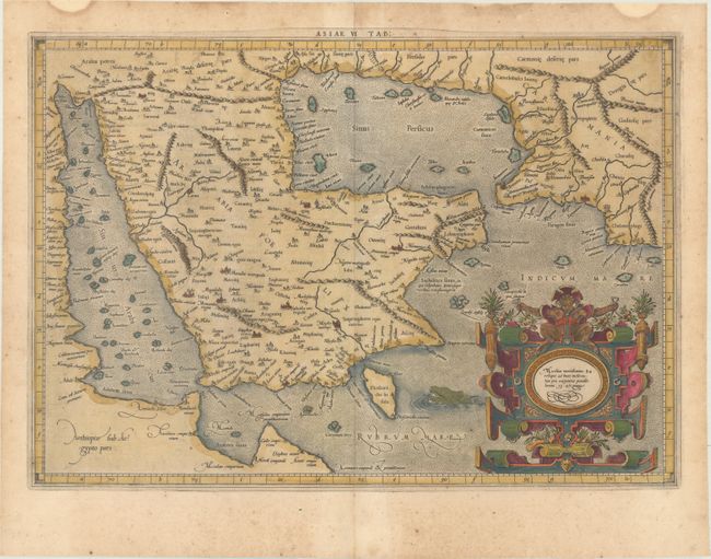
This classical map is a landmark in the mapping of the Arabia Peninsula. Ptolemy drew on the accounts of travelers and sailors and though the information was secondhand and often inaccurate it represented the most advanced account of the world's geography at that time. In the case of Arabia, Ptolemy overestimated both the width of the southern part of Arabia and the size and shape of the Persian Gulf. Arabia Petrea and Arabia Deserte are both placed in the north and Arabia Foelix is the term applied to the whole peninsula, rather than to the southern portions of it. Ptolemy's map, as interpreted by European cartographers such as Mercator, was hugely influential and served as a standard for European mapping of the peninsula for many years. This is the first state of this map, with the original cartouche, which was re-engraved in 1695. Latin text on verso with an alternate title: Asiae Tabula Sexta.
Mercator originally published this map in his 1578 edition of Ptolemy's great Geography. Although he is most renowned today for the projection he popularized and for first using the term Atlas for a collection of maps, he devoted much of his life to his Ptolemaic maps. The maps were beautifully engraved as nearly as possible to their original form and embellished with fine cartouches. Published in Petrus Bertius' Theatrum Geographiae Veteris…, which included maps by Mercator and Ortelius.
References: Ankary #113; Mickwitz & Miekkavaara #232-22; Tibbetts #40; Van der Krogt (Vol. I) #0926:1.1.
Condition: B+
Light toning and scattered foxing with two small damp stains in the top blank margin.