Subject: Black Sea, Ukraine & Russia
Period: 1788 (dated)
Publication:
Color: Hand Color
Size:
25.4 x 17.3 inches
64.5 x 43.9 cm
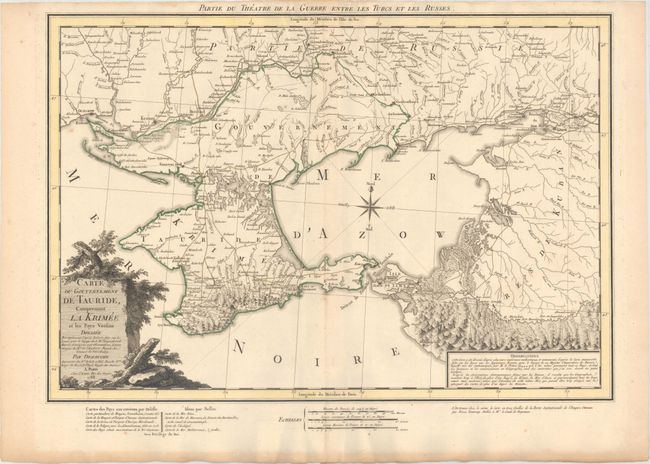
This rare map depicts the theater of war during the Russo-Turkish War that began in 1787, just one year before the publication of the map. At the end of the previous Russo-Turkish War, Russia had annexed the Crimean Khanate, but the Ottomans sought to regain the territory. The Ottomans failed in their attempt, and the war ended with the Treaty of Jassy in 1792 with Russia maintaining control over the region surrounding the Sea of Azov, as shown here. The map gives great detail of the rivers, roads, towns and topography of the land. Dezauche credits the cartography to the Saint Petersburg Academy of Sciences, now known as the Russian Academy of Sciences. The Academy was founded in 1724 and was responsible for several important explorations, including Vitus Bering's Second Kamchatka Expedition from 1733-43. The map is embellished with a compass rose and a title cartouche on a stone plinth surrounded by vegetation. Below the map are advertisements for maps by Delisle, Bellin, and a three-sheet map by Rizzi Zannoni.
References:
Condition: A
A sharp impression with original outline color on watermarked paper and light toning along the edges of the sheet.