Subject: Black Sea
Period: 1705 (published)
Publication: Algemeene Weereld-Beschryving…
Color: Hand Color
Size:
9.4 x 7 inches
23.9 x 17.8 cm
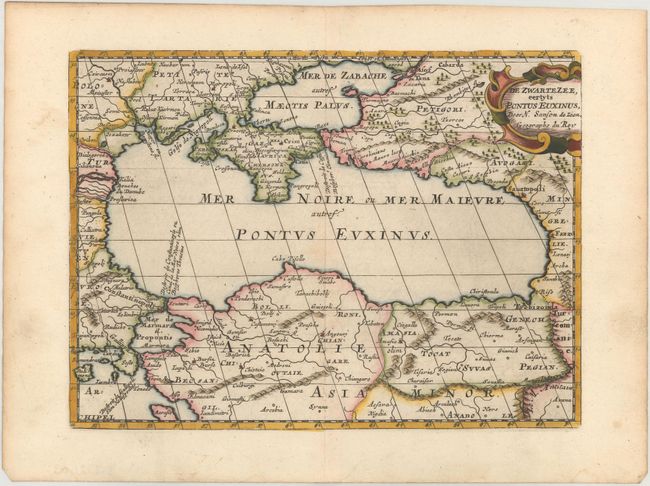
Small, attractive map of the lands surrounding the Black Sea showing major cities and rivers, including portions of present-day Turkey, Romania, Russia, Bulgaria, Ukraine and the Sea of Azov. Decorated with a strapwork title cartouche. Engraved by Antoine de Winter.
This map appeared in Algemeene Weereld-Beschryving, nae de Rechte Verdeeling der Landschappen, Plaetsen, Zeeën, Rivieren, &c. Geographisch, Politisch, Historisch, Chronologisch en Genealogisch, a Dutch edition of A. Phérotée de la Croix's Nouvelle Methode Pour Apprendre Facilement la Geographie Universelle, which first appeared in 1690. The Dutch edition was published by Francois Halma and included 98 maps and views. Halma acquired many of the plates for Algemeene Weereld-Beschryving from Joannes Ribbius, who had enlisted the services of engraver Antoine de Winter to make copies of the maps in Nicolas Sanson's quarto atlases of the four continents. De Winter made very few geographical changes and maintained the attribution to Sanson on the newly engraved plates. Halma supplemented the Sanson maps with about a dozen new maps engraved in the same style as Sanson's, without any attribution on the maps, as well as 23 panoramic views of famous cities around the world.
References:
Condition: A
A crisp impression with a hint of toning along the centerfold and light toning along the edges of the sheet.