Subject: Basse-Terre, Guadeloupe
Period: 1760 (dated)
Publication: General Topography of North America and the West Indies
Color: Hand Color
Size:
18.6 x 12.8 inches
47.2 x 32.5 cm
Thomas Jefferys was one of the most important English map publishers of the 18th century. His work included prints and maps of locations around the world, but his most notable maps are of North America and the West Indies. He began his career in the map trade in the early 1730s, working as an engraver for a variety of London publishers, and eventually setting up his own shop. In 1746, he was appointed Geographer to the Prince of Wales, and in 1760 he became Geographer to the King. These titles granted access to manuscripts and cartographic information held by the government. In the early 1760s he embarked on an ambitious project to produce a series of English county maps based on new surveys, but ran out of money and filed for bankruptcy in 1766. He then partnered with London publisher Robert Sayer, who reissued many of Jefferys plates and continued to issue new editions after Jefferys' death in 1771. Jefferys' American Atlas and the accompanying West-India Atlas, published post posthumously, are considered his most important cartographic works.
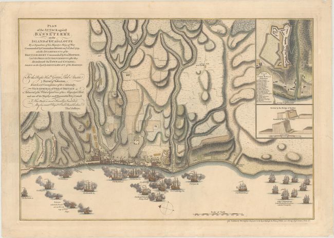
This superb map depicts the British military action against French forces on Guadeloupe on January 22, 1759. The invasion of Guadeloupe took place during the Seven Years' War and was a hollow victory for the British due to the number of lives lost due to illness both during and after the invasion. The island was returned to French control at the end of the war as a result of the Treaty of Paris of 1763. This plan shows the layout of the city, the entrenchments of the French, and locations of various ships, along with the number of guns aboard each. The inset at top right gives a close-up plan of Fort Royal with a lettered key identifying important locations and profile views of portions of the fortifications.
References: Shirley (BL Atlases) T.JEF-1a.
Condition: A
Crisp impression on paper with a Strasbourg bend and lily watermark. There are archival repairs to several chips and tears all confined to the blank margins.