Subject: Texas
Period: 1856-86 (circa)
Publication:
Color: Hand Color
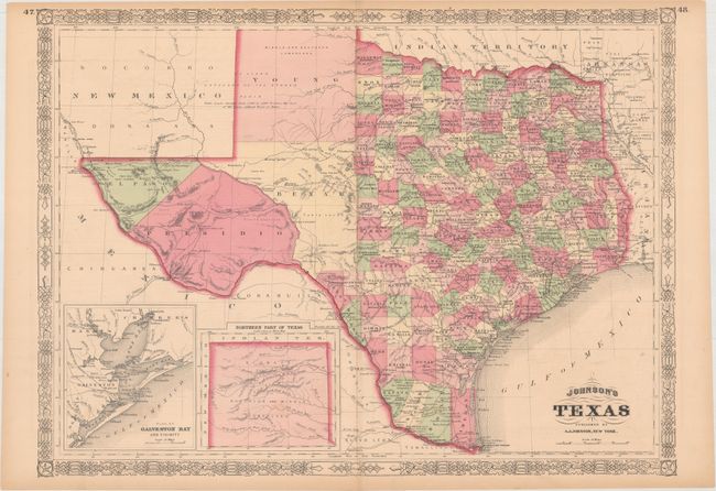
A. Johnson's Texas, by A.J. Johnson, dated 1866 (23.2 x 17.1"). A large, handsome map with county development mostly in eastern Texas and only the large counties of El Paso, Presidio, Bexar, and Young in the west. The panhandle is noted as the Staked Plain. There are nice depictions of the wagon roads, many named, with several completed railroads. Includes insets of "Plan of Galveston Bay and Vicinity" and "Northern Part of Texas." Surrounded by a decorative latticework border. Condition: Light toning along the sheet edges with two small edge tears confined to the bottom margin that have been closed on verso with archival tape. (B+)
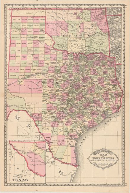
B. Tunison's Texas and Indian Territory,, by H.C. Tunison, circa 1886 (12.9 x 19.5"). In Tunison's style, this is a finely lithographed map with original bright coloring. By this period most mapmakers had adopted printed color rather than the more labor intensive hand coloring employed here. It is decorated with a Victorian style border and title cartouche, which gives the population of Texas as 1,591,749 and no population reported for Indian Territory. At lower left is an inset "The Western Part of Texas on Reduced Scale." The panhandle of Oklahoma is Public Lands. Indian Territory is clearly divided into about 20 different Indian lands. Green County, originally established in 1860, is here unnamed and still part of Texas. It was abolished and awarded to Indian Territory by a Supreme Court decision in 1896. There is good detail of railroads with all stops located and named. Tunison's maps were printed on both sides; on the verso are single-page maps of Nebraska and Alabama. Condition: A clean, bright example with a few faint spots. (A)
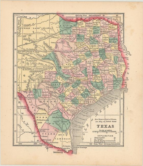
C. Texas, by Morse & Gaston, from The Diamond Atlas, circa 1856 (5.4 x 6.4"). This small map covers eastern Texas with the railroad network prominently depicted. The western, non-county portion of the map is identified as Comanche Indians with the Fannin Land District to its north. Condition: There are a few faint spots of foxing in the right blank margin, else fine. (A)
References:
Condition:
See description above.