Subject: Colonial Saratoga, New York, Revolutionary War
Period: 1780 (dated)
Publication: A State of the Expedition from Canada…
Color: Hand Color
Size:
13.9 x 13.5 inches
35.3 x 34.3 cm
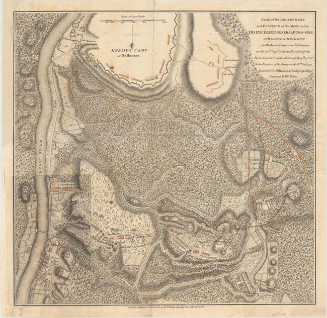
This detailed and uncommon battle plan shows the placement of British and American forces during the second Battle of Saratoga (also known as the Battle of Bemis Heights), which took place in October 1777. The two battles were fought nineteen days apart, and the interesting overlay at bottom left shows the change in positions of the two armies over that time period, with the Americans advancing north (with north oriented to the bottom). These overlays were located at the end of the atlas and could be hinged to the map. Saratoga was a key victory for the Americans, leading to an alliance with the French that brought critical military aid. The map uses hand color to depict the troop positions and is from John Borgoyne's A State of the Expedition from Canada..., published in London. Faden's maps of the American Revolution are particularly well presented because he based them on manuscript maps supplied to him from the war zone.
References: Nebenzahl (Biblio) #56; Nebenzahl (Amer. Rev.) #22.
Condition: B+
Issued folding on watermarked paper with light toning and offsetting. There is a 2" fold separation at top that has been archivally repaired on verso and a binding trim at top left that has been replaced with old paper.