Subject: Western New York
Period: 1810 (circa)
Publication:
Color: Black & White
Size:
9.8 x 8.6 inches
24.9 x 21.8 cm
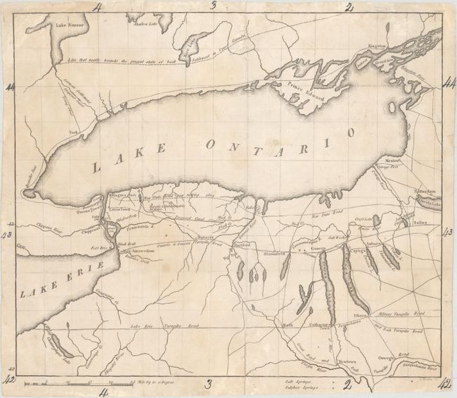
This small, untitled map is the first known map to be engraved by Samuel Harrison. Harrison was responsible for some of the most important cartographic efforts of the period including the Lewis & Clark map of western North America (1814), Samuel Lewis' United States map (1815-16), 22 maps in Fielding Lucas' New and Elegant General Atlas (1816-17), William Darby's famous Louisiana and Mississippi maps (1816-17), Melish's map of Indiana (1817), Melish's United States of America (1818), and finally the Sturgis Early Map of the State of Georgia (1818).
The map was issued in The Port Folio, a Philadelphia-based publication that ran from 1801-1827. It emphasizes the evolving transportation network of this frontier region from the Finger Lakes to Lake Erie, and north to Lake Ontario. Numerous wagon roads are identified including the Lake Erie Turnpike, Ontario & Genesee Turnpike, a "New State Road now making 1809," and a proposed canal. Also notes "Hepatic & Inflammable Air Holes" just south of Lake Ontario. An uncommon issue made significant by its engraver.
References:
Condition: B
Issued folding and now flattened with centerfold separations that enter approximately 1" into the image at top and bottom that have been repaired on verso with archival materials. Several small edge chips confined to the top and bottom blank margins have also been archivally repaired on verso. Light soiling with manuscript notations in the margins.