Subject: Japan & Korea
Period: 1655 (circa)
Publication: Novus Atlas Sinensis
Color: Hand Color
Size:
22.4 x 16.5 inches
56.9 x 41.9 cm
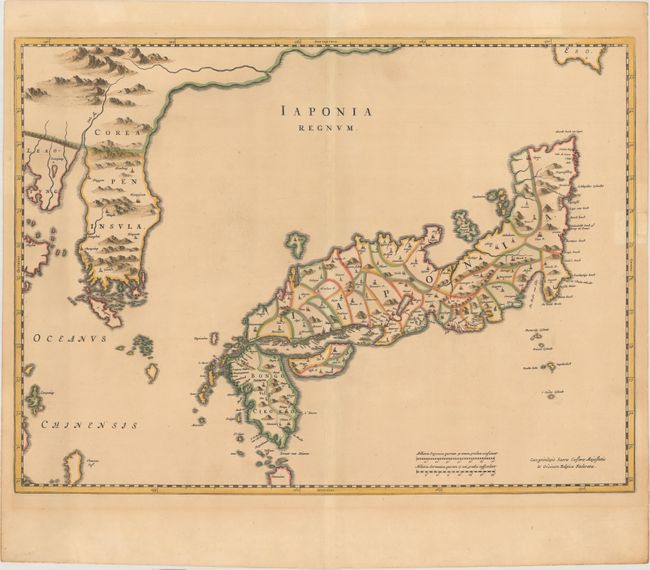
This important map of Japan provided the most accurate depiction of the general outlines of the principal islands of Japan for more than a century. It was also the first map to correctly show Korea as a peninsula. The maps from the Atlas Sinenis were prepared by Martino Martini, an Italian Jesuit who lived in China. His map of Japan was not drawn from first-hand knowledge, but compiled from information obtained in China and from the previous Jesuit Blancus/Moriera map. Blaeu added much of the nomenclature and the more detailed depiction of the Izu Islands, most likely from unpublished charts of the Dutch East India Company. It depicts the internal administrative divisions with a few major cities. There is also some evidence of Jesuit missions with some town symbols surmounted by a small cross. The Martini/Blaeu map was extremely influential and was copied extensively by other mapmakers through the remainder of the 17th century. This is the second state, with a privilege that reads "Cum privilgeio Sacrae Caesarae Majestatis & Ordinum Belgicae Foederatae."
References: Goss (Blaeu) #100 p. 222; Hubbard #27.2; Van der Krogt #8450.2; Walter #38 & OAG #28.
Condition: B+
A nice impression on a lightly toned sheet with archival repairs to a tiny tear east of Japan, a tear that enters about 1" into map at right, and two 1" tears east of Korea. A piece of hinge tape is in the right blank margin on recto.