Subject: Monterey Bay, California
Period: 1797 (published)
Publication: Atlas du Voyage de La Perouse
Color: Black & White
Size:
19.4 x 13.3 inches
49.3 x 33.8 cm
Jean-Francois de Galoup, Comte de La Perouse commanded a French scientific expedition to the Pacific in 1785-88. Recognized as one the foremost naval commanders and navigators in France, he was selected by King Louis XVI to complete Captain James Cook's exploration of the western Pacific. The British Admiralty provided scientific equipment to measure variations in magnetic compass readings and with the latest instruments for determining longitude. La Perouse explored the coasts of the Gulf of Alaska and northwestern North America in search of the fabled Northwest Passage. After leaving America his expedition continued on to Asia where he explored from Macao to Kamchatka and the Solomon Islands in the South Pacific. La Perouse was meticulous in sending copies of his extensive logs, maps and surveying information via other ships as well as overland. La Perouse's last contact was in the spring of 1788 with a British ship in Botany Bay, Australia. The expedition was never heard from again. Considered one of the greatest French voyages, the French Government decided to publish the story of the expedition when it became clear they had been lost. An English edition was published in London.
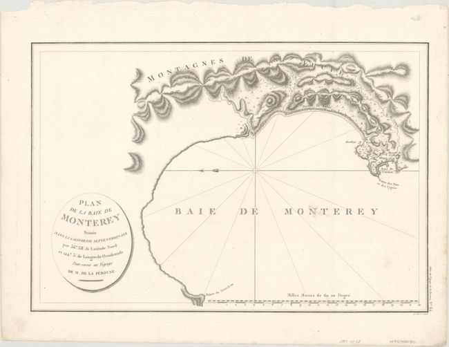
This is the first French edition of this wonderful, early plan of Monterey Bay. The map is oriented with north to the left and shows the entire bay and sweeping coastline from Pointe de Nouvel-au (Santa Cruz) to Pointe des Pins ou des Cypres, near today's Carmel. It locates the Presidio and Mission of St. Charles, anchorages, rocks, and the coastal range inland, including the Saint Lucia Range. During his voyage around the world, La Perouse landed at Monterey in September of 1786, where he remained for nine days, before setting out for the Philippines. La Perouse's map of Monterey is the only one of his California maps derived entirely from original sources and is the earliest obtainable map of the region for collectors. Engraved by L. Aubert.
References: Phillips (Atlases) #688-15; Wagner (NW) #847.
Condition: B+
A dark impression on a clean sheet. There is a small worm track at center that has been infilled with archival materials with a portion of the "N" and "T" in "Monterey" replaced in facsimile.