Subject: Southwestern United States
Period: 1862 (dated)
Publication: HR Ex. Doc. No. 1, 37th Congress, 3rd Session
Color: Black & White
Size:
28 x 21.1 inches
71.1 x 53.6 cm
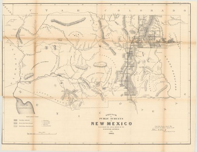
Early, large-scale, territorial map by the Surveyor Generals Office, Santa Fe, New Mexico. It includes all of today's Arizona and extends to show the northern reaches of the Sea of Cortez, California, at the west and Colorado and Utah to the north. The area of present-day New Mexico is depicted with limited surveying, primarily the settled areas of Santa Fe, Albuquerque, and along the valley of the Rio Grande River. Place names include Dona Ana, El Paso and Ft. Bliss, Ft. Craig, Taos, the Hopi Pueblos, San Francisco Mountain, Ft. Buchanan, Ft. Yuma, Tucson, San Xavier, Tubac, and more. The center of the territory is noted as Unexplored. Present-day Phoenix appears as Maricopa Wells. Most of Arizona is blank with little cartographic information save a few rudimentary rivers, two Indian Reservations, and mountain ranges. Hachuring indicates private land claims, Pueblo Indian grants, and townships subdivided.
References:
Condition: B
Issued folding with light toning along the fold lines. A few small fold separations have been closed on verso with old tape, with some tape stains are visible on recto at left. A binding trim at top left has been trimmed to just inside the neatline.