Subject: North America, United States
Period: 1839-46 (dated)
Publication: Mitchell's School and Family Geography
Color: Hand Color
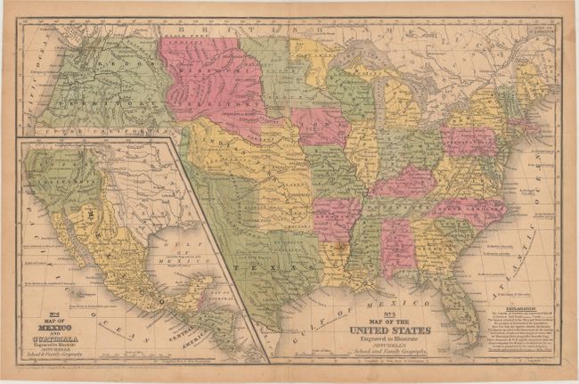
A. No. 5 Map of the United States, dated 1839 (16.4 x 10.4"). This early map has terrific western territorial borders featuring the Independent Republic of Texas with the long stovepipe border extending well above Pike's Peak to the 42nd parallel. Austin is shown as the Republic's capital city. It names Bexar, Victoria, Columbia, Houston, Franklin, and Galveston. Notations within Texas include "Herds of Buffaloes and Wild Horses," "Mustang Desert," and "Extensive Prairies." The Great American Desert extends from the panhandle up into the large Indian Territory. The huge Missouri Territory lays between the even larger Oregon Territory and extends to meet the new state of Iowa and Iowa Territory at the Missouri River. The large Indian Territory fills the region from Texas to Missouri Territory along the North Fork of the Platte River, west to Texas and east to border with Missouri and Arkansas. The large inset "No. 6 Map of Mexico and Guatimala" shows Mexico in control of the entire Southwest up to Oregon Territory and eastward to Texas. An early Mitchell map that was engraved by W. Williams.
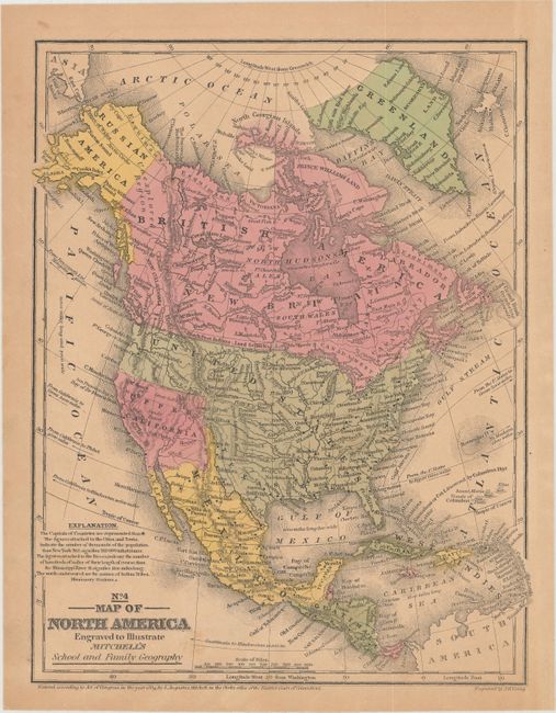
B. No. 4 Map of North America, dated 1839 (8.1 x 10.3"). This map shows a large Independent Texas extending to the 42nd parallel and the United States extending to the Pacific. Mexico is in control of Upper California. Alaska is Russian America with the Aleutian Peninsula labeled Alaska. Canada is depicted as British America and New Britain. Names numerous Indian tribes, major towns with good detail of major rivers, and a vague idea of the Rocky mountains. The Great Basin is here called the Sandy Desert.
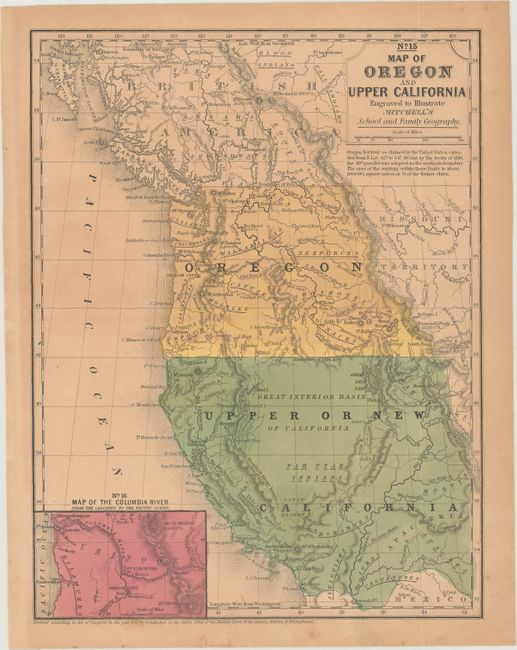
C. No. 15 Map of Oregon and Upper California, dated 1846 (7.9 x 10.4"). This is the smaller school atlas version of Mitchell's well-known map which is based largely on Fremont's map of 1845. This edition has the US/Canadian boundary as we know it today with the notation "Boundary of 1846." Upper California extends eastward to the Rio Grande and Oregon Territory to the Continental Divide. The map delineates the Oregon Route (Oregon Trail) in good detail as it winds from the Sweetwater River through South Pass to Oregon City. Numerous Indian tribes and villages and forts are located. An early depiction of the Great Basin is here called the Great Interior Basin of California. At lower left is the inset "Map of the Columbia River from the Cascades to the Pacific Ocean" which locates Oregon City, Ft. Vancouver, a mission on the Columbia, Mt. Hood, and Mt. St. Helens with a height of 13,300 feet.
References:
Condition: B+
Overall light toning and minor soiling/staining. The map of the United States also has a 2" centerfold separation at bottom that has been repaired on verso with archival tape. Overall condition is better than usually seen for maps issued in school geography books.