Subject: Exploration & Surveys
Period: 1720 (published)
Publication:
Color: Black & White
Size:
4 x 6.7 inches
10.2 x 17 cm
This fascinating volume, published by Jean Frederic Bernard, includes the accounts of various explorers in North America, two folding maps, and 17 engravings related to Native Americans. The volume encompasses two works in one - volumes V and VI of Bernard's Recueil de Voyages au Nord. The first work is Relations de la Louisiane, et du Fleuve Mississipi..., which describes the explorations of Louis Hennepin, Henri de Tonti, Bartholomew Gosnold, Martin Pring, and an anonymous officer's account. Tonti's account, first published as Dernieres Decouvertes dans l'Amerique Septentrionale de ... La Sale..., appears here in its second French edition as Relation de la Louisiane; et du Mississipi and is considered one of the most important histories of the Mississippi Valley in the 17th century. Hennepin's account, Voyage en un Pays plus Grand que Europe, Entre la Mer Glaciale & le Nouveau Mexique is a later edition of his second book. The second work is Recueil d'Arrests et Autres Pieces pour l'Etablissement de la Compagnie d'Occident - Relation de la Baie de Hudson, les Navigations de Frobischer, au Detroit qui Porte son Nom, which describes the accounts of Martin Frobischer, Nicolas Jeremie, and M. Crosat. The volume is accompanied by the following two maps:
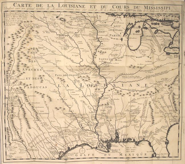
A. Carte de la Louisiane et du Cours du Mississipi... This is a reduced-size edition of Delisle's influential map of the French possession of Louisiana that drew together the cartographic work of the previous half century and had a tremendous impact on the history of cartography. When originally published in 1718, it was the first detailed map of the Gulf region and the Mississippi, and the first to show the explorations of De Soto, Cavelier, Tonty, Moscoso and Denis. The map was designed for the political purpose of invalidating the English claims west of the Appalachian Mountains and laid claim to Carolina by the French, which provoked an angry English response. The name Texas made its first appearance in print on the earlier edition of this map, with the legendary Mission de los Teijas, established in 1716. The notation of Indiens errans et anthrophages along the Gulf Coast warns of cannibals. However, it is the cartography of the Mississippi Valley for which the map is notable today. Due to the reduced scale, this edition omits the inset depicting the mouth of the Mississippi.
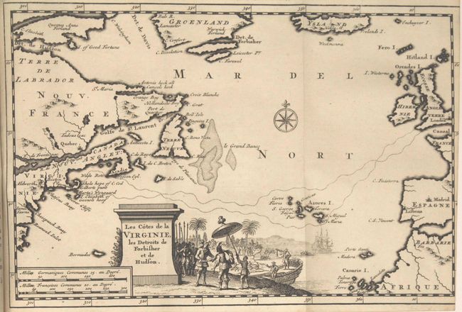
B. Les Cotes de la Virginie, les Detroits de Forbisher et de Hudson. This is the French edition of Pieter van der Aa's map of the North Atlantic that shows parts of the European, African and American continents with Iceland and Greenland at top. From the report of Martin Pring's journey from England to New England in 1603, the sea routes of Captain Pring from the British Isles through the Azores to Plymouth are depicted. Virginia extends into what is present-day Massachusetts as well as the Chesapeake Bay area. The large title cartouche is surrounded by a fabulous scene of the colonists and Native Americans greeting each other.
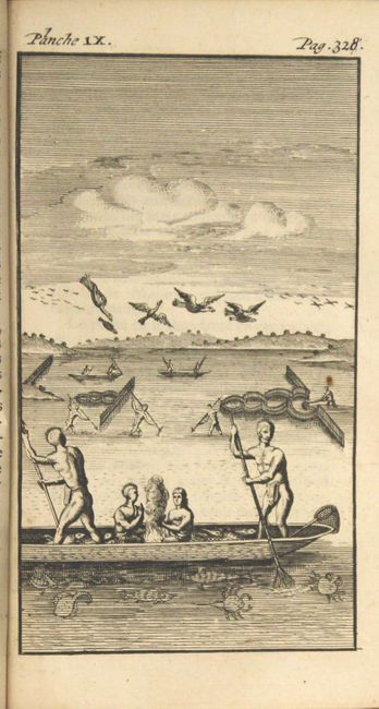
Also included are 17 engravings related to Native Americans, with 14 of them based on John White's illustrations in De Bry. 408 pp., 253 pp., 100 pp., 2 folding maps, 17 single-page engravings. Hardbound in vellum.
References: Cumming (SE) #175; Howes #T294; Tooley (Amer) p.22, #44; Sabin #68419 & #69299.
Condition: B+
The map of Louisiana is a sharp impression with faint offsetting, a couple of rust spots, and light scattered foxing at top left. There is a 1/2" binding tear at far right. The map of the North Atlantic was trimmed within the neatline at right by the bookbinder. The plates and text are very clean and bright with an occasional spot of foxing. The covers are lightly soiled and the spine has begun to crack.