Subject: Northwestern Africa
Period: 1541 (published)
Publication: Claudii Ptolemaei Alexandrini Geographicae…
Color: Black & White
Size:
18.2 x 11.1 inches
46.2 x 28.2 cm
Claudius Ptolemy was a mathematician, astronomer and geographer who worked in Alexandria, then a part of the Roman Empire, in the 2nd century AD. One of the most learned and influential men of his time, his theories dominated both astronomy and geography for nearly 1500 years. His writings were kept alive by Arabic scholars during the Middle Ages and reemerged in Europe during the Renaissance. The birth of printing led to wide dissemination of his great works on astronomy and geography. There were a number of editions of his Geographia beginning in 1477. These early editions contained maps based on his original writings, known as Ptolemaic maps. As geographic knowledge increased with the explorations of Columbus, Magellan, Cabot and others, maps of the New World were added, and maps of the Old World were revised. Ptolemy's Geographia continued to be revised and published by some of the most important cartographers including Martin Waldseemuller, Sebastian Munster, Giacomo Gastaldi, Jodocus Hondius, and Gerard Mercator (whose last edition was published in 1730).
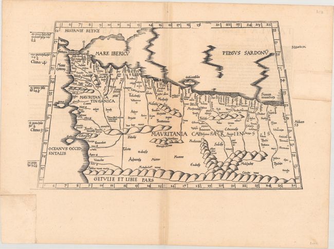
This fine Ptolemaic map is from the wood blocks of Laurent Fries, the famous physician, astrologer and geographer. The map covers northwestern Africa showing the regions that would become Morocco and Algeria and including the Strait of Gibraltar, here called Fretum Herculen. The topography is dominated by large rivers, convoluted mountain ranges, and the locations of ancient cities are noted. Title is from the verso, which contains Latin text. This edition was printed by Gaspar Treschel and edited by Michael Villanovus (known as Servetus). Servetus was charged with heresy by John Calvin in 1553, in part due to the text in this atlas. The courts found him guilty and sentenced him to burning at the stake, atop a pyre of his own books, including this atlas.
References: Mickwitz & Miekkavaara #211-11.
Condition: B+
A dark impression with a few tiny centerfold separations and uneven light toning mostly around the centerfold. Portions of the blank margins have been reinstated with old paper at top right and bottom left.