Subject: Sri Lanka
Period: 1578 (published)
Publication: Claudii Ptolemaei Alexandrini Geographiae…
Color: Hand Color
Size:
14 x 13.5 inches
35.6 x 34.3 cm
Claudius Ptolemy was a mathematician, astronomer and geographer who worked in Alexandria, then a part of the Roman Empire, in the 2nd century AD. One of the most learned and influential men of his time, his theories dominated both astronomy and geography for nearly 1500 years. His writings were kept alive by Arabic scholars during the Middle Ages and reemerged in Europe during the Renaissance. The birth of printing led to wide dissemination of his great works on astronomy and geography. There were a number of editions of his Geographia beginning in 1477. These early editions contained maps based on his original writings, known as Ptolemaic maps. As geographic knowledge increased with the explorations of Columbus, Magellan, Cabot and others, maps of the New World were added, and maps of the Old World were revised. Ptolemy's Geographia continued to be revised and published by some of the most important cartographers including Martin Waldseemuller, Sebastian Munster, Giacomo Gastaldi, Jodocus Hondius, and Gerard Mercator (whose last edition was published in 1730).
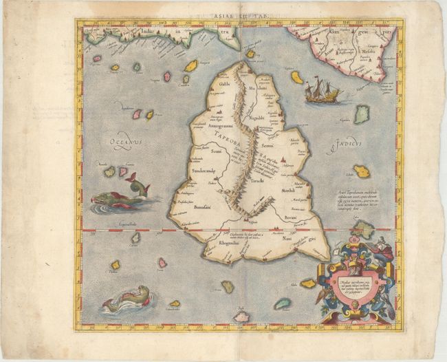
For this map of Toprobana (Sri Lanka), Ptolemy drew on the accounts of travelers and sailors and though the information was secondhand and often inaccurate, it represented the most advanced account of the world's geography at that time. This map depicts the island with the typical misconceptions of the period with the enlarged island straddling the Equator and nearly divided by a ridge of mountains. A small part of India is incorrectly shown in the northeast corner of the map and a spurious coastline labeled Gangem fills the upper right corner. The stipple engraved sea contains an oriental ship and two great sea monsters. This edition is from the original plate without the decorative title cartouche. The cartouche at lower right identifies the location of the island and a mapmaker is perched on one of the elaborate straps. Latin text on verso.
References: Mickwitz & Miekkavaara #221-28; Van der Krogt (Vol. I) #0932:1.1.
Condition: B+
A crisp impression on paper with a large coat of arms watermark, some printer's ink residue at top, a tiny tear near the center that has been professionally repaired, and light damp stains that just enter the map border at top.