Subject: Holy Land
Period: 1639 (circa)
Publication: Historica, Theologica et Moralis Terrae Sanctae Elucidatio
Color: Hand Color
Size:
33 x 12.7 inches
83.8 x 32.3 cm
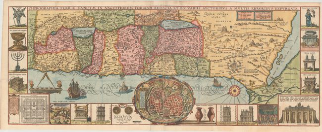
Panels illustrating sacred objects surround this stunning map of the Holy Land. Oriented with east at top, the map includes the territories of the twelve tribes on both sides of the Jordan River and the route of the Exodus and Wandering. At center is an inset bird's-eye plan of ancient Jerusalem based on the Spanish biblical geographer, Juan Bautista Villalpando. The decorative panels include a menorah, the arc of the covenant, the altar of sacrifices, the Tabernacle, and a plan and elevations of the Temple. Two sheets joined as issued.
This map was engraved by Pieter Verbiest, whose imprint appears at bottom left of the large Holy Land map. Published in Franciscus Quaresmius' Historica, Theologica et Moralis Terrae Sanctae Elucidatio. This is a rare variant of this map that we have not seen before.
References: cf. Laor #771.
Condition: A
Issued folding on watermarked paper with a few small holes and one short separation along the folds, all but the tiniest of which have been closed on verso with old paper. There are remnants of hinge tape along the edges of the sheet on verso.