Subject: Western Hemisphere - America
Period: 1571 (published)
Publication: Theatrum Orbis Terrarum
Color: Hand Color
Size:
19.9 x 14.4 inches
50.5 x 36.6 cm
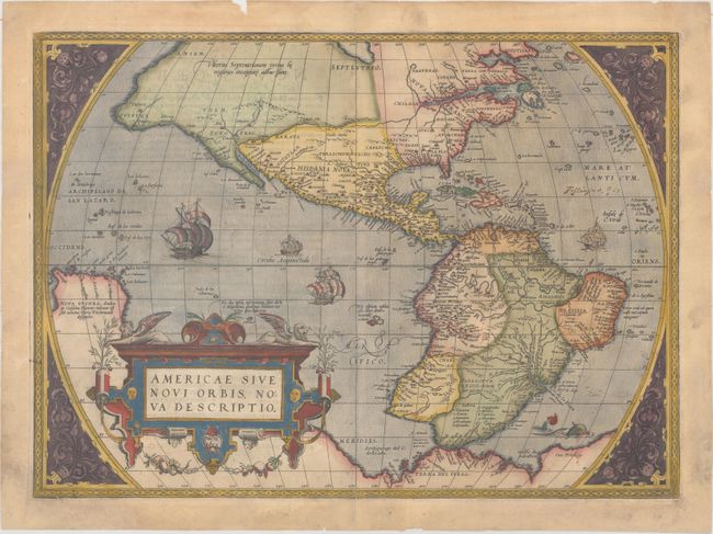
This is one of the most famous maps of America, and one that had enormous influence on the future cartography of the New World. Frans Hogenberg engraved this map, and it is primarily based on Gerard Mercator's great multi-sheet world map of 1569. The most recognizable features of the map are the bulbous Chilean coastline and the exaggerated breadth of the North American continent. North America shows a lengthy St. Lawrence River reaching across the continent to nearly meet the fictitious, westward flowing Tiguas Rio. The strategically placed title cartouche hides the unknown South Pacific and therefore most of the conjectural great southern continent, which is shown attached to both New Guinea and Tierra del Fuego.
This is from the uncommon first plate (second state), published in the Latin edition of 1571. This plate had a relatively short life and was published only between 1570 and 1575.
References: Burden #39.2; Goss (NA) #11; Van den Broecke #9.2.
Condition: B+
Attractive old color on a sheet of watermarked paper with light surface soiling mostly in the blank margins. There are two small chips in unengraved areas adjacent to the centerfold at top that have been professionally repaired on verso, and a short edge tear at bottom that extends 0.75" into the image that has been closed on verso with hinge tape. Small chips in the blank margins have been expertly infilled, and there are a few additional edge tears confined to the blank margins that have been closed with archival materials on verso.