Subject: Ancient World
Period: 1619 (published)
Publication: Theatrum Geographiae Veteris
Color: Hand Color
Size:
14.9 x 6.4 inches
37.8 x 16.3 cm
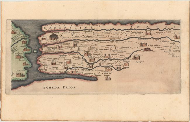
This sheet is the rare "9th segment" of the famous Peutinger Table. This decorative strip map depicts the imperial roads and posts within the Roman Empire. The format distorts the landmasses, but provides an excellent view of the cities and roads, which include distances between the posts.
The original parchment document for this incredible map is thought to have been made in the thirteenth century, and showed the roads within the Roman Empire throughout Europe, North Africa and Asia as far as Toprobana (Sri Lanka). The original now resides in the Vienna National Library, but is so damaged that the Ortelius version is now the most reliable representation. The Peutinger Table, as it is generally known, derived its name from Konrad Peutinger, who once owned the original. Ortelius had manuscript copies made in 1598 from the original scroll and supervised the engraving, but did not live to see their publication. Ortelius' Peutinger Table was published posthumously in several editions of his Theatri Orbis Terrarum Parergon, which is credited with popularizing the Peutinger Table.
In 1619, Petrus Bertius included the plates for Ortelius' Peutinger table without the accompanying text in his Theatrum Geographiae Veteris, which was published by Jodocus Hondius. Bertius added a 9th segment that was created exclusively for his atlas and was not republished elsewhere. This 9th segment is actually a re-engraving of approximately the top half of the 1st segment of the Peutinger Table.
References: Rumsey #11296.096.
Condition: A
A dark impression with light toning along the edges of the sheet.