Subject: Pennsylvania
Period: 1880 (published)
Publication:
Color: Printed Color
Size:
5.6 x 8.8 inches
14.2 x 22.4 cm
This lot of maps comes from the Second Geological Survey of Pennsylvania. The survey began after the Civil War and was overseen by J. P. Lesley, who became state geologist in 1875 and served in that capacity until 1889. These maps all relate to the oil regions in Pennsylvania and were published in an atlas volume to The Geology of the Oil Regions of Warren, Venango, Clarion, and Butler Counties, including Surveys of the Garland and Panama Conglomerates in Warren and Crawford, and in Chautauqua Co., N.Y... by John F. Carll. This lot includes 19 (of 22) maps from the atlas:
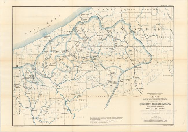
Plate 1. Map of North Western Pennsylvania Showing the Outlines of the Summit Water Basins
Plate 2. Map of North Western Pennsylvania, Showing the Outlines of the Summit Water Basins
Plate 3A. From Meadeville to Sugar Grove; from Hazen's Coal Bank to Miller's Quarry; Ridge Between Jamestown and Adamsville
Plate 3B. Topographical Map Showing the Breadth and Depth of Spring Creek and Brokenstraw Valleys in Warren County
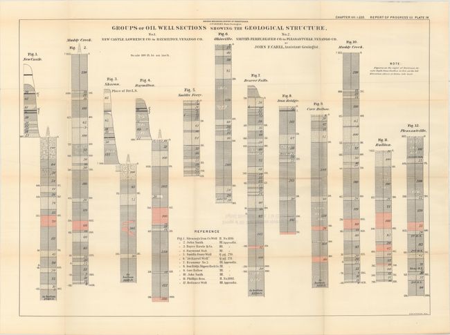
Plate 4. Groups of Oil Well Sections Showing the Geological Structure (Figs. 1-12)
Plate 5. Groups of Oil Well Sections Showing the Geological Structure (Figs. 13-21)
Plate 6. Groups of Oil Well Sections Showing the Geological Structure (Figs. 22-30)
Plate 7. Groups of Oil Well Sections Showing the Geological Structure (Figs. 31-39)
Plate 8. Diagram Map and Section Showing the Dip of the Venango Third Sand
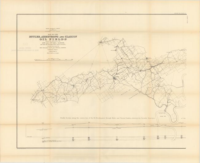
Plate 9. Butler, Armstrong and Clarion Oil Fields. West Sheet
Plate 9. Butler, Armstrong and Clarion Oil Fields. East Sheet
Plate 10. Generalized Geological Section from Black Rock, New York, to Dunkard Creek, Pa.
Plate 12. Groups of Oil Well Sections Showing the Geological Structure (Figs. 74-83)
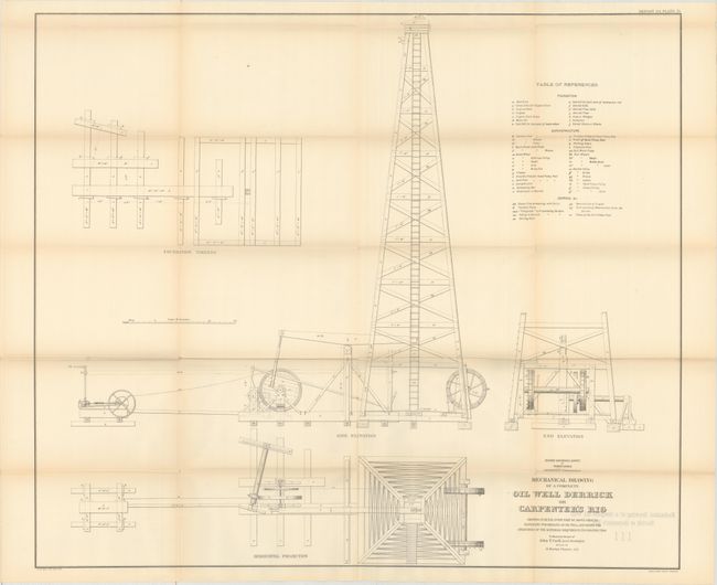
Plate 13. Mechanical Drawing of a Complete Oil Well Derrick
Plate 14. Mechanical Drawing of Cross Sections of Wells Nos. 1, 2, 3
Plate 15. Three Oil Well Sections Intended to Illustrate the Progressive Deepening of the Borings
Plate 16. A Detailed Drawing of the Principal Tools Used in Drilling Oil Wells
Plate 18. A Map of the Vicinity of Franklin, in Venango County, Showing an Ancient Water Course
Plate 19. Topographical Map to Illustrate the Varied Features of Erosion in the Vicinity of Titusville and Pleasantville
This set appears to be missing Plate 11 (Vertical Section from the Upper Barren Coal Measures down to the Corniferous Limestone), Plate 17 (Diagram of Daily Rate of Drilling Six Petrolia Wells), and Plate 20 (Geological Colored Map of Venango County). The maps are all issued separate and housed in the original hard cloth-covered boards with gilt title on spine and ribbon ties.
References:
Condition: B+
Maps are overall very good with light toning and short separations along the fold intersections. The covers are lightly worn and stained.