Subject: Western United States
Period: 1862-73 (circa)
Publication:
Color: Hand Color
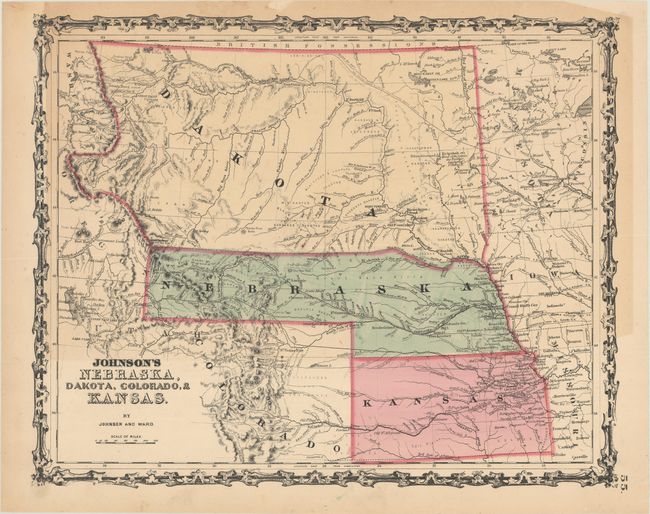
A. Johnson's Nebraska, Dakota, Colorado, & Kansas, by Johnson and Ward, circa 1862 (15.5 x 12.4"). This colorful map features Nebraska with a long panhandle that extends all the way to about present-day Idaho near Ft. Bridger and Fremont's Peak. Above Nebraska is a huge Dakota Territory that extends all the way to the Canadian border, west to the Continental Divide and east to Minnesota Territory. The map is filled with information and locates numerous Indian tribes, trading posts, wagon roads and trails, exploration routes, mountain peaks, and more. Shows the railroad routes explored by Gov. Stephens, Lt. Beckwith, and Capt. Gunnision, as well as numerous forts and early settlements. The Oregon Trail is shown but not named and several other emigrant roads are shown including several converging on Denver. Names the North, Middle, and South Parks, as well as several forts and a few towns in Colorado. Colorado’s western boundary is not defined and the former Utah designation remains just above the “C” in Colorado indicating an 1862 date is likely. Condition: There is some light toning along the upper two-thirds of the sheet. (B+)
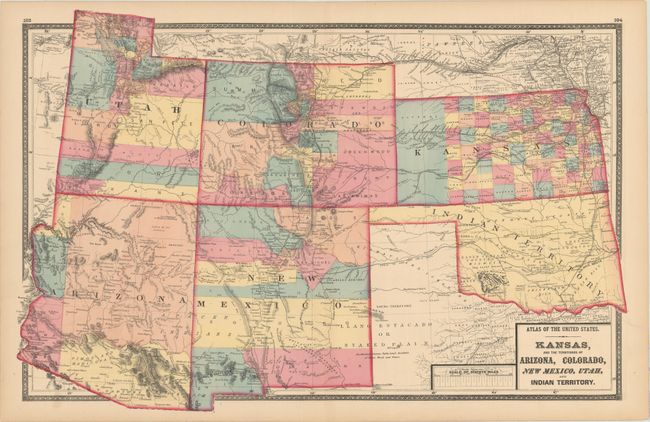
B. Kansas, and the Territories of Arizona, Colorado, New Mexico, Utah, and Indian Territory, by Stedman, Brown & Lyon, from Atlas of the United States, circa 1873 (25.1 x 16.4"). An uncommon, striking, double-page map of the American Southwest. Arizona depicts only 5 counties with a huge Yavapai County occupying the majority of the territory. Western Kansas is dominated by Shyenne County, and the Staked Plain is prominently shown in western Texas. The map is filled with roads, railroads, Indian tribes, as well as the U.S. Mail Route, Sante Fe Road, and Santa Fe and Fort Smith Road. Condition: Strong hand coloring on a clean sheet. (A)
References:
Condition:
See description above.