Subject: Philippines
Period: 1705 (published)
Publication: Algemeene Weereldbeschryving
Color: Hand Color
Size:
9.7 x 7.5 inches
24.6 x 19.1 cm
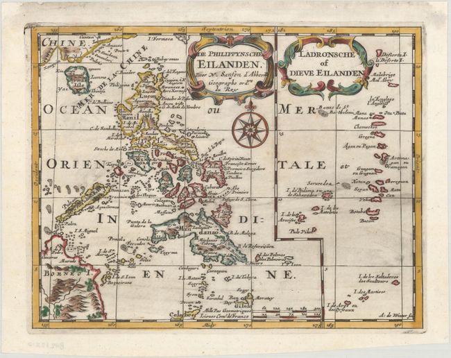
Two interesting maps of the Philippines and Marianas on one sheet, each decorated with a beautiful title cartouche. The map describes many place names on the islands, and shows a bit of Borneo at the bottom and some of China's southern coastline at the top. The sheet is decorated with a very lovely compass rose. Engraved by Antoine d'Winter. Published in Francois Halma's Dutch edition of A. Pherotee de la Croix's Nouvelle Methode Pour Apprendre facilement la Geographie Universelle.
Sanson's small maps from his L'Asie en Plusieurs Cartes..., first published in 1652 and engraved by A. Peyrounin, were copied several times by various map publishers. Johann David Zunners made copies of Sanson's maps for his German translation of Die Gantze Erd-Kugel in 1679. Johannes Ribbius and Simon de Vries published copies in 1682 and 1683, with new maps engraved by Antoine d'Winter. The plates were later sold to Francois Halma, who used them in 1699 and then again in 1705 with the titles re-engraved in Dutch. The titles on the d'Winter plates were re-engraved back into French, and then used by Nicholas Chemereau in 1715 and by Henri du Sauzet in 1738.
References:
Condition: A
A dark impression on a clean, bright sheet with light printer's ink residue. There are professional repairs to a worm track in southern Mindanao with a minute amount of image replaced in facsimile and to several small chips and tears along the edges of the sheet.