Subject: World
Period: 1750 (circa)
Publication:
Color: Black & White
Size:
20.6 x 7.6 inches
52.3 x 19.3 cm
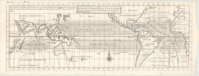
This is an Italian edition of Moll's chart that describes the world between about 50° north and south latitude. This includes southern Newfoundland to just north of Tierra del Fuego. The chart shows nearly blank continents with just country names and little else. Its main focus is an extremely detailed view of sea-borne winds. The legend explains the lines and arrows used to delineate the coasting winds and the shifting trade winds. The arrows suggest the prevailing direction, but some are annotated with month or season to indicate a periodic wind rather than a year-round, reliable trade wind. Largely based on the work of the English scientist Sir Edmund Halley. Published in an Italian edition of Thomas Salmon's Modern History: or the Present State of All Nations.
References: cf. Shirley (BL Atlases) G.SALM-1c #39.
Condition: A
A crisp impression on a bright sheet with a small binding trim at lower right that has been replaced with old paper. Issued folding.