Catalog Archive
Auction 164, Lot 721

"A Map of the Discoveries Made by Capts. Cook & Clerke, in the Years 1778 & 1779 Between the Eastern Coast of Asia and the Western Coast of North America...", Wilkie, J. & T.

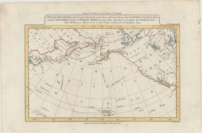
Subject: North Pacific Ocean

Period: 1787 (dated)

Publication: Hervey's New System of Geography

Color: Hand Color

Size:
11.1 x 7.6 inches
28.2 x 19.3 cm
Download High Resolution Image
(or just click on image to launch the Zoom viewer)

This chart details the track of the explorations of Captain Cook in 1778 & 1779 including the ill fated stop in Hawaii, here called the Sandwich Islands. It covers the area from eastern Asia and Japan to California. The Aleutian chain is labeled the Northern Archipelago. Dotted lines show the routes traveled by the explorers. Engraved by William Palmer. This edition appeared in Frederick Hervey's A New System of Georgraphy... and was published by G. & T. Wilkie.

References: cf. McCorkle (18th C. Geography Books) #111-13;cf. Wheat & Brun #24.

Condition: A

A nice impression with a few minor spots. There are some short edge tears and light soiling confined to the blank margins.

Estimate: $110 - $140

Sold for: $80

Closed on 9/13/2017

Archived