Subject: Pacific Ocean, California
Period: 1745 (published)
Publication: Atlas van Zeevaart en Koophandel door de Geheele Weereldt
Color: Hand Color
Size:
22.4 x 19.3 inches
56.9 x 49 cm
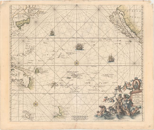
This superb chart was originally issued by Frederick de Wit in 1675, and updated by Reiner and Joshua Ottens. It is centered on the Pacific Ocean and shows the island of California with an indented northern coast on the second Sanson model. The important Dutch discoveries are noted on the northern coast of Australia: Carpentaria, New Guinea, Anthoni van Diemens Landt (Tasmania), and New Zealand. North of Japan the discoveries of De Vries are shown along with disembodied sections of Terre de Iesso and Terre de la Compagnie. The Ottens have updated the chart to include the Solomon Islands and Land of the Holy Ghost, but followed De Wit in omitting the hypothetical coastline of the southern continent. The chart is elegantly adorned with rhumb lines, sailing ships, sea battles, and two compass roses. The allegorical title cartouche features a portrait of Magellan, cherubs, and Neptune with a female consort riding a brace of sea-horses.
References: McLaughlin #226; Tooley (America) p. 122, #41; Tooley (Australia) #1373.
Condition: A
A dark impression with original color in the map and later color in the decorative elements. There is some minor repair work to several edge chips and tears, but all are confined to the blank margins.