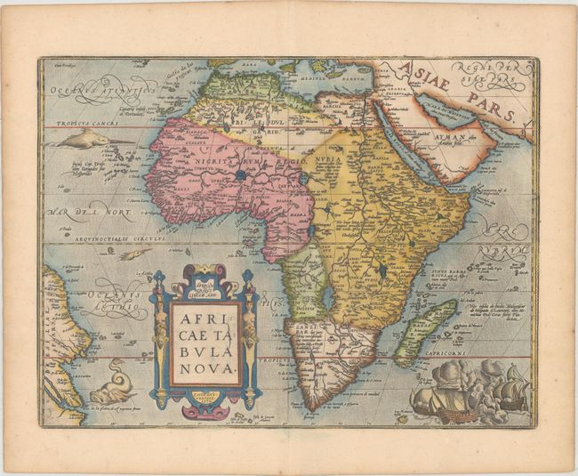
Subject: Africa
Period: 1570 (dated)
Publication: Theatrum Orbis Terrarum
Color: Hand Color
Size:
19.8 x 14.8 inches
50.3 x 37.6 cm
This striking map is one of the cornerstone maps of Africa and remained the standard map of Africa well into the seventeenth century. It was designed by Ortelius from elements of contemporary maps by Gastaldi, Mercator, and Forlani and used several recent sources: Ramusio in Navigationi et Viaggi (1550), Joao de Barros in Decadas da Asia (1552), and Leo Africanus in Historiale description de l'Afrique (1556). The majority of the nomenclature is taken from Gastaldi. The Nile is based on the Ptolemaic concept, originating from two large lakes south of the equator. Curiously Ortelius did not represent the Mountains of the Moon (a prominent feature on most prior maps) and the twin lakes are not named. Ortelius introduced two important changes to the shape of the continent on this map; the Cape of Good Hope is more pointed, and the eastward extension of the continent was reduced significantly. The map is decorated with a strapwork title cartouche, a grand sea battle (copied from Diego Gutierez' wall map of the Americas), and sea monsters. The presence of the ghost monster is barely visible in the sea off the Arabian peninsula. This beautiful map was engraved by Frans Hogenberg who engraved many of the maps for the Theatrum. This is the fifth state with a colon added after Oceanus Aethio and the emergence of a crack along the right-hand letters in the title cartouche. Latin text on verso, published in 1603.
References: Betz #12.5; Van de Broecke #8; Norwich #10.
Condition: A
A sharp impression on watermarked paper with light toning along the edges of the sheet.