Subject: Amsterdam, Netherlands
Period: 1730 (circa)
Publication:
Color: Hand Color
Size:
38.1 x 22.3 inches
96.8 x 56.6 cm
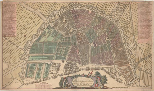
This rare, two-sheet bird's-eye plan of Amsterdam views the city from the northeast, across the IJ. The map is based on the city plan compiled in 1662 by architect Daniel Stalpaert and published by Nicolas Visscher, which recorded the addition of the Ring Canals to the city that had begun in 1613. The plan shows the streets, canals, locks, city blocks, and a number of important landmarks in great detail. The streets are numbered and keyed to columns flanking the map, listing an impressive 299 streets. The city is divided into 14 districts, which are numbered with gilt highlights. Dozens of galleons fill the waterfront, demonstrating the importance of Dutch trade at the time, and numerous windmills surround the city. The decorative title cartouche features putti, garlands of fruit, and the coat of arms of Amsterdam. Printed on two sheets, joined as issued.
References:
Condition: B
A nice impression with full original color and gilt highlights. There is light soiling, two small, dark stains at left, and some light damp stains at top and right. There are four short tears (0.5" to 2" in length) at far right that have been closed on verso with archival tape. A 6" strip of masking tape was placed along the top left edge of the sheet on verso, which has since been removed with remnants only visible on verso.