Subject: Gulf of Mexico
Period: 1741 (circa)
Publication:
Color: Hand Color
Size:
22.3 x 17.7 inches
56.6 x 45 cm
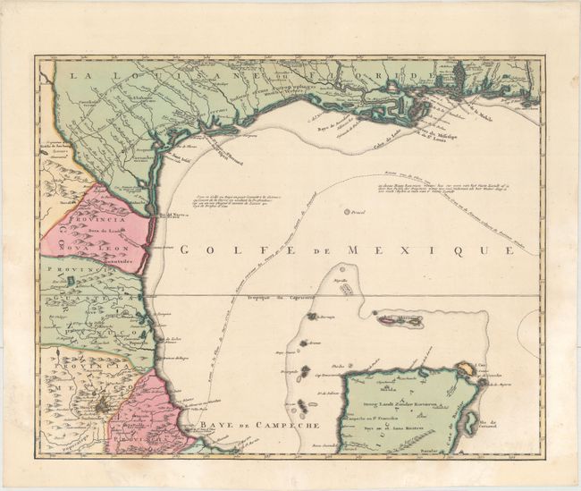
This is the northwestern sheet of Ottens' 6-sheet map of the Gulf of Mexico and the Caribbean depicting the theater of the War of Jenkins' Ear, part of the War of the Austrian Succession. The War of Jenkins' Ear had an improbable and theatrical origin. After fifty years of colonial boundary disputes and growing trade competition in the New World, relations between Britain and Spain were extremely strained. The war was named after Robert Jenkins, captain of the ship Rebecca, who claimed Spanish coast guards had cut off his ear in 1731. Seven years later Jenkins was invited by a party of warmongers to tell his story and display his ear to Parliament, thereby inflaming British and colonial American opinion against Spain. There was an increasing perception by the English that the Spanish were restricting their access to the slave trade in the West Indies. This friction was aggravated by a continuing dispute over the border between Spanish Florida and Georgia. These mounting issues compelled Prime Minister Walpole to declare war on Spain in October, 1739.
This map depicts the Gulf of Mexico from St. Joseph Bay, Florida to Veracruz, Mexico, and includes the tip of the Yucatan peninsula and the island of Cozumel. Texas, which had been largely ignored on maps of the Americas, is shown on a large scale with excellent detail. The mission at Cenis and Fort Francas are shown, and the routes of explorers La Salle and St. Denis are depicted. The map also details the mouth of the Mississippi River and shows several important cities and forts, including New Orleans, Natchitoches, Fort Biloxi, Fort St. Louis, and Fort Carolin. In the Gulf is a note in French and Dutch explaining that the distance from shore at any given point is equal to the depth in soundings. Also shown is the route of the Spanish treasure fleets from Veracruz to Havana.
This map was first issued separately, as the Ottens' wanted to capitalize on the increased interest in the War of Jenkins' Ear, and published each sheet of the 6-sheet map as it was printed in 1740-41. The full set of 6 maps was not available until June 1741, and the individual maps were also included in made-to-order composite atlases. As a result, this map is not commonly found on the market.
References: Lowery #356; Phillips (Atlases) #3495:117.
Condition: A
A sharp impression with full original color. Large chips confined to the bottom corners of the sheet (and not affecting the image) have been professionally replaced with period-correct paper.