Subject: Southwestern United States & Mexico
Period: 1863 (dated)
Publication: Sen. Ex. Doc. No. 1, 37th Congress, Special Session
Color: Black & White
Size:
14.2 x 6.4 inches
36.1 x 16.3 cm
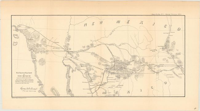
This important map covers the majority of New Mexico Territory and southern California to include Los Angeles and Mexico south to the town of San Francisco. It was drawn by Cyrus H. De Forrest, 1st Lt and Aid-de-camp to Fergusson. The map notes several "Practicable Rail Road" routes across the region and into Mexico. Also locates silver, gold and copper mines including the Stevensons Silver Mines east of Dona Anna. Several forts are noted including Yuma, Craig, Thorn and Fillmore. Near today's Puerto Penasco is a Shell Observatory, a location we've not previously seen on any map. Fergusson was charged with making a survey of Port Lobos and Libertad on the Gulf of California to determine whether "Arizona and the Mesilla valley" could be supplied from Kansas City or from Texas. His explorations further demonstrated the viability of a railroad route to the Pacific via a southern route. Wheat considered this the only military map of note produced in 1862 and to which he devotes an entire page of description.
References: Wheat (TMW) #1042.
Condition: B+
Issued folding with several short fold separations that just pass the neatline and have been repaired on verso with archival tape. Light toning along sheet edges.