Subject: Chicago, Illinois, Lake Michigan
Period: 1840 (published)
Publication: Sen. Doc. 140, 26th Congress, 1st Session
Color: Black & White
Size:
10.7 x 10.9 inches
27.2 x 27.7 cm
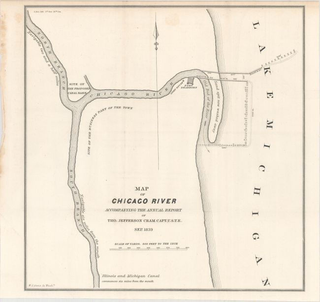
This is one of the earliest printed maps to focus on the vicinity of Chicago. It shows the Chicago River and a sand spit jutting into Lake Michigan noted as "now washed away." Fort Dearborn, a light house, the Site of the Business Part of the Town, and the Site of the Proposed Canal Basin are located.
This map was issued in the 26-page Report from the Secretary of War, Transmitting Copies of Reports of the Topographical Bureau in Relation to Internal Improvements in the Territory of Wisconsin... by Captain Thomas Jefferson Cram of the Topographical Engineers (report not included). Cram (1804-1883) was born in New Hampshire and graduated fourth in his class from the United States Military Academy in West Point, New York. In 1838, he joined the U. S. (Army) Topographical Engineers, where he received a captain's commission and was assigned to the Great Lakes harbor surveys. In the 1840s he surveyed the Michigan and Wisconsin boundary, and in 1855 he became Chief of the Topographical Engineers, Western Division. He was promoted to Lt. Colonel in 1861, served with distinction in the Civil War and was rewarded with the title of Brevet General in 1866. He retired in 1869.
References: Claussen & Friis #331.
Condition: A
The map is clean and bright with just a hint of offsetting and one faint spot. Dog-eared at bottom left where the map folded into the report.