Subject: Southwestern United States & Mexico
Period: 1802 (dated)
Publication: Descubrimiento y Conquista de la America...
Color: Black & White
Size:
17.9 x 12.6 inches
45.5 x 32 cm
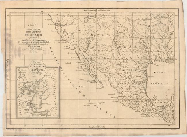
This very rare map of the Southwest and Mexico was issued in D. Juan Corradi's Descubrimiento y Conquista de la America o Compendio de la Historia General del Nuevo Mundo, published in Madrid in 1803. The map incorporates the latest Spanish information available with cartography based upon Bernardo de Miera Y Pancheco's Plan de la Provinca Interna de el Nuevo Mexico (1778). It is quite unusual to see this level of detail on a printed map dated 1802, as this highly guarded information was not available to the public until Humboldt's landmark map of 1811. It shows the R.S. Buenaventura running southwest into the Great Salt Lake, and from the west the i>R. de los Dolores reaches too far inland and nearly connects to the lake. This misconception would continue until Fremont's explorations in the 1840s. Outside of the river systems, there is limited inland detail beyond a few place names and basic topographical features. The map is augmented by an inset of Mexico City and its surroundings. Drawn by Gonzalez and engraved by Morata. A highly unusual Spanish map of the American southwest.
References: cf. Cohen [Mapping the West] p. 66.
Condition: B+
Issued folding on watermarked paper with light staining along the left border. A tiny binding tear at left just passes the neatline.