Subject: Southern United States & Mexico
Period: 1603 (published)
Publication: Tabularum Geographicarum, Contractarum...
Color: Black & White
Size:
4.9 x 3.4 inches
12.4 x 8.6 cm
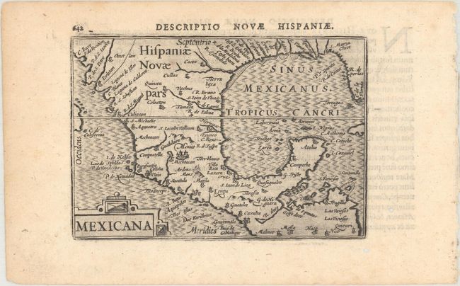
Charming miniature map of Mexico and the whole coastline of the Gulf of Mexico. The map appears to be based in part on Cornelis de Jode's Americae Pars Borealis (1593). Mexico City is shown prominently, with a smoking volcano just to the south. A number of other cities are labeled in Mexico, while only rivers and capes are noted in the US. The Rio Grande River is identified as R. Escondido. Adorned with a strapwork title cartouche. Latin text on verso.
This map first appeared in Barent Langenes' Caert-Thresoor (Map Treasury), which had a complicated publishing history. The Map Treasury was first published by Langenes in 1598 with maps by several well-known engravers, including Jodocus Hondius and Pieter van den Keere, and was sold by both Langenes and Cornelis Claesz. Several editions of the Map Treasury were published through 1609. In 1600, the maps from the Map Treasury were reissued with new text by Petrus Bertius and published by Claesz under the title Tabularum Geographicarum, Contractarum Libri Quatuor. Editions of Bertius' Tabularum Geographicarum appeared in Latin and German through 1650, with the latest editions published by Visscher and Jan Jansson.
References: Burden #114; King (2nd ed.) pp. 80-82; Van der Krogt (Vol. III) #9510:341.
Condition: A
A dark impression with two small worm holes in the blank margins.