Subject: Texas
Period: 1857 (published)
Publication:
Color: Black & White
Size:
4.8 x 7.4 inches
12.2 x 18.8 cm
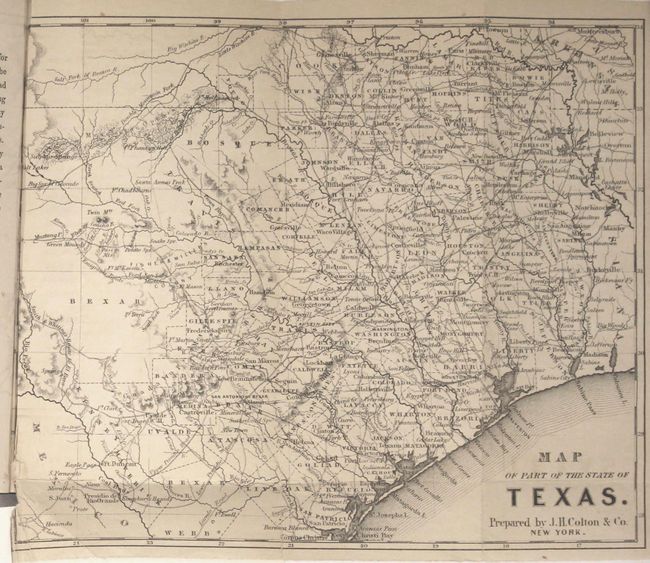
This scarce map (9 x 7.3") appeared in Frederick Law Olmsted's account of his saddle-trip through Texas from 1856-57. The map omits the Pan Handle, Big Bend and the Valley counties south of Webb County, and is one of the few pre-civil war Texas maps to show the road system, rather than railroads. Counties, county seats, and topography are also well depicted. Numerous forts are named, including Fort Martin Scott, Fort Clark, Fort Territ, Fort Inge, Fort Ewell, Fort Phantom Hill, and Fort McKavette. County lines are approximately up to date for 1857, although there is no sign of Jack county and Bexar district is already named. Other interesting features are a German settlement in Llano county, an Emigrants Route from Fort Mason to the Green Mounds, and Smith & Whiting's Route to El Paso. The map was prepared by Joseph Hutchins Colton.
Frederick Law Olmsted, known by many as the father of American Landscape Architecture, was commissioned by the New York Daily Times (now The New York Times) to conduct a research journey through the American South and Texas from 1852 to 1857. His reports to the Times were collected into three volumes (A Journey in the Seaboard Slave States (1856), A Journey Through Texas (1857), A Journey in the Back Country in the Winter of 1853-4 (1860)) and served as thorough and accurate first-person accounts of the pre-war South. His correspondence on Texas included both observations and statistical research on customs, food, housing, agriculture, business, weather, and the influence of slavery.
References: Howes #O79; Sabin #57243.
Condition: B+
The map has light toning along the top edge, a few spots of foxing at top, and a couple of short fold separations at bottom that have been archivally repaired on verso. The map has a binding trim at bottom left with the bottom left corner creased and a bit fragile, and is bound tight into the volume up to the neatline. The text is clean and bright and the new covers have a rectangular piece of the spine cut out at bottom.