Subject: Texas
Period: 1825-27 (published)
Publication: Atlas Universel de Geographie...
Color: Hand Color
Size:
20.3 x 18.3 inches
51.6 x 46.5 cm
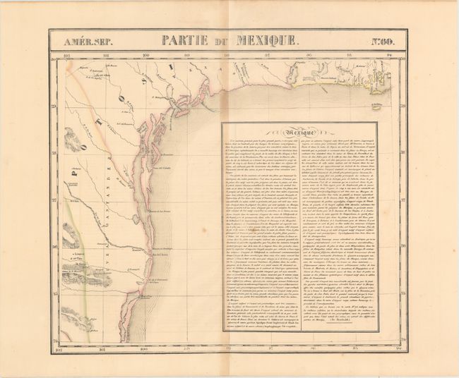
Vandermaelen was the son of a wealthy industrialist who abandoned his father's business to follow a career in cartography. His goal was to produce the first atlas ever published in which every map was drawn on the same projection and to the same scale (1: 1,641,836), with each map covering an area of approximately 20 degrees of longitude (from Paris) and 6 degrees of latitude. Because of the consistent scale and projection, the maps could be joined together to form a huge globe that would measure over 25 feet in diameter. Vandermaelen had the only known globe constructed from his maps, requiring a special room for its display. It was also the first lithographic atlas ever published. There was one edition of the atlas, published in 1825-27, and the subscription list shows that only 810 copies were sold. Koeman called his Atlas Universel, "One of the most remarkable world atlases ever made. Far ahead of its time."
This is one of the earliest accurate maps devoted specifically to the Texas coast. The information was gathered from Spanish sources and Humboldt’s Carte Generale...Nouvelle Espagne (1809). There is a jumble of islands dotting the coast from Galveston Bay (here called Baie Trinidad) to the mouth of the Rio Grande (Rio del Norte). Laredo, San Antonio, Galveston, and Ft. Matagorda are located but there is no sign yet of any Anglo settlements. In addition to the Texas coast, this elegant map shows a small part of Mexico and Louisiana. A large box at right contains extensive text on mining in Mexico from Humboldt.
The Atlas Universel was the first atlas to present all the maps on the same scale (1: 1,641,836) about one inch to 26 miles, with each map covering an area of approximately 10 degrees longitude (from Paris) and 6 degrees of latitude. It was also considered to be the first lithographic atlas ever published. The maps were meant to be joined together to form a huge globe measuring 7.775 meters in diameter. Only one edition of the atlas was published in 1825-27, and the subscription list shows that just 810 copies were sold; thus the maps are very scarce on the market today.
References:
Condition: B+
Original outline color with light toning along the centerfold, faint text offsetting, and a few spots of foxing.