Subject: North America
Period: 1825-27 (published)
Publication: Atlas Universel de Geographie...
Color: Hand Color
Size:
24.3 x 19.5 inches
61.7 x 49.5 cm
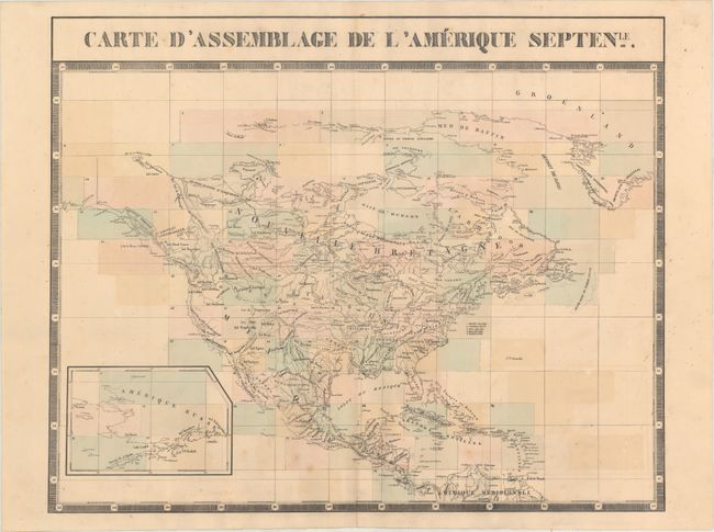
Vandermaelen was the son of a wealthy industrialist who abandoned his father's business to follow a career in cartography. His goal was to produce the first atlas ever published in which every map was drawn on the same projection and to the same scale (1: 1,641,836), with each map covering an area of approximately 20 degrees of longitude (from Paris) and 6 degrees of latitude. Because of the consistent scale and projection, the maps could be joined together to form a huge globe that would measure over 25 feet in diameter. Vandermaelen had the only known globe constructed from his maps, requiring a special room for its display. It was also the first lithographic atlas ever published. There was one edition of the atlas, published in 1825-27, and the subscription list shows that only 810 copies were sold. Koeman called his Atlas Universel, "One of the most remarkable world atlases ever made. Far ahead of its time."
This is the index map of North America to Vandermaelen's monumental Atlas Universel. Vandermaelen's maps of the American West are a landmark in the history of cartography and this key sheet presents the major topographical features along with the locations of major Indian tribes. Alaska is shown in an inset. The maps in this atlas were all presented on a uniform scale (1: 1,641,836), and each map covered an area of approximately 10 degrees longitude (from Paris) and 6 degrees of latitude. The maps were meant to be joined together to form a huge globe measuring 7.775 meters in diameter. It was also considered to be the first lithographic atlas ever published. Only one edition of the atlas was published in 1825-27, and the subscription list shows that just 810 copies were sold; thus the maps are very scarce on the market today.
References:
Condition: B+
Original color with light color offsetting and a few spots of foxing.