Subject: World
Period: 1550 (circa)
Publication: Cosmographia
Color: Hand Color
Size:
15 x 10.4 inches
38.1 x 26.4 cm
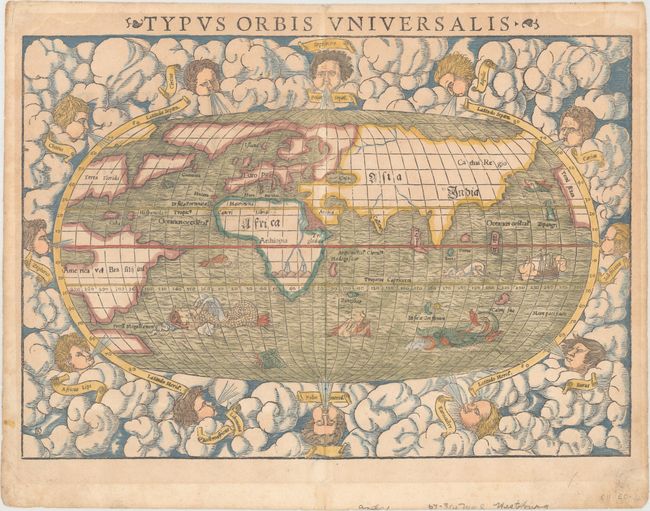
Sebastian Munster (1489 - 1552) was one of the three most renowned cartographers of the sixteenth century, along with Mercator and Ortelius. Munster's Geographia and Cosmographia Universalis were two of the most widely read and influential books of the period. His editions of Ptolemy's Geographia, published between 1540 and 1552, were illustrated with 48 woodcut maps, the standard 27 Ptolemaic maps supplemented by 21 new maps. These new maps included a separate map of each of the known continents and marked the development of regional cartography in Central Europe. The antique geography was a prelude to Munster's major work, the Cosmographia, which was published in nearly 30 editions in six languages between 1544 and 1578 and then was revised and reissued by Sebastian Petri from 1588 to 1628. The Cosmographia was a geographical as well as historical and ethnographic description of the world. It contained the maps from the Geographia plus additional regional maps and city views with nearly 500 illustrations which made it one of the most popular pictorial encyclopedias of the sixteen century.
This famous woodblock map is presented on an oval projection surrounded by clouds and wind heads with the title above the map. The continents are shown in rough outline only. North America is shown with the large cleft nearly separating the east coast from the continent, often referred to as the Sea of Verazano. What appears to be a large Northwest Passage stretches towards Asia. South America has a very strange shape as well. In Africa, the Nile is prominently shown with its twin sources beginning in a range of southern mountains. The mythical islands of Grisonum and Calensuan are placed in the proximity of Australia, where there is also the label Mare Pacificum. A sailing ship and several fierce sea monsters occupy the oceans. Initials of the engraver David Kandel in lower left-hand corner. This is the second 'modern' world map to appear in Munster's Cosmographia, published between 1550 and 1578. This example is from a Latin edition, with Latin text on verso.
References: Shirley #92; Manasek #12.
Condition: B+
Light toning, one tiny hole in the image, marginal soiling, and a few small chips confined to the blank margins that have been professionally repaired.