Subject: Florida
Period: 1846 (dated)
Publication:
Color: Black & White
Size:
40 x 42.1 inches
101.6 x 106.9 cm
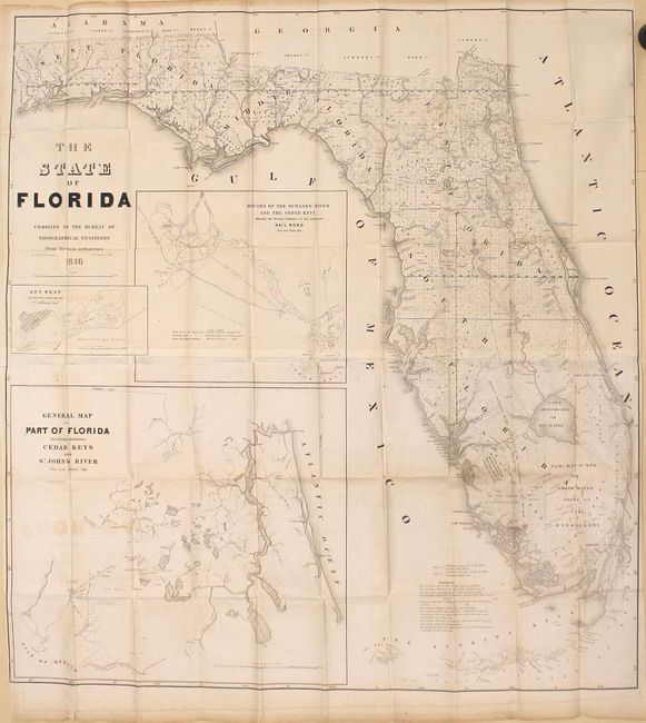
A very large and comprehensive map of Florida that was published just one year after gaining statehood. The map includes great detail of the status of Public Land Surveys, rivers, lakes, coastal islands, towns, army posts, trails, etc. The surveys extend south of Cape Canaveral, with the majority of the southern portion of the state still unsurveyed with the exception of along the coastlines. The Everglades are identified along with a notation regarding the land assigned to Native Indians: "District assigned to the Seminoles by the arrangement of Gen.' Macomb May 18th 1839." Three large inset maps fill the Gulf of Mexico: "Key West as surveyed February 1829"; "Mouths of Swanee R. and Cedar Keys showing the Western terminus of a proposed railroad"; and "A General Map of part of Florida included between Cedar Keys and St. John's River." The map was drawn by Joseph Goldsborough Bruff and finely engraved by D. McClelland of the Topographical Engineers. Bruff was a draftsman and cartographer who served as a mapmaker for both the United States Army and the Bureau of Topographical Engineers. After news of the gold rush reached Washington DC, Bruff organized the Washington City and California Mining Association and led an expedition to California to seek gold. Printed on two sheets and joined, as issued.
References: Phillips (Maps) p. 284.
Condition: B+
Issued folding with light toning, light offsetting, and numerous short splits at fold intersections. A binding tear at top left that enters 1.75" into the image has been closed on verso with archival tape. Narrow side margins, as issued.