Subject: Western United States
Period: 1851 (published)
Publication: A New Universal Atlas...
Color: Hand Color
Size:
12.9 x 15.5 inches
32.8 x 39.4 cm
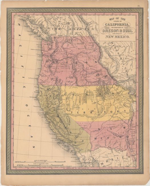
A great map of the western territories and the new state of California from this superb series of maps originated by Samuel A. Mitchell in 1846. Oregon Territory takes in all of present day Washington and Idaho and is bounded in the east by Missouri Territory. The huge Utah Territory (formed in 1850) covers the region labeled Fremont Basin and stretches from the California border to just past the Rocky Mountains. Salt Lake City is noted as the Mormon Set. New Mexico Territory (also formed in 1850) encompasses parts of present-day Colorado and Arizona and its southern boundary is on the Gila River - pre Gadsden Purchase. The Gold Region is clearly marked along the Sacramento River and there is no county development shown in the new state. The Oregon Route, Great Spanish Trail from P. Angeles to Santa Fe, Lewis and Clarkes route and several other early trails are shown. The copyright at bottom, by H.N. Burroughs, is dated 1845 although the map was published in 1851. The map number "37" reflects renumbering of maps in this atlas issue to accommodate the Texas map after Louisiana.
References: Wheat (TMW) #684; Wheat (Gold) #168.
Condition: B+
Full original color with light toning and a number of short edge tears, several of which just pass the neatline.