Subject: Colonial Southern United States
Period: 1706 (circa)
Publication: Naaukeurige Versameling...
Color: Black & White
Size:
8.9 x 6 inches
22.6 x 15.2 cm
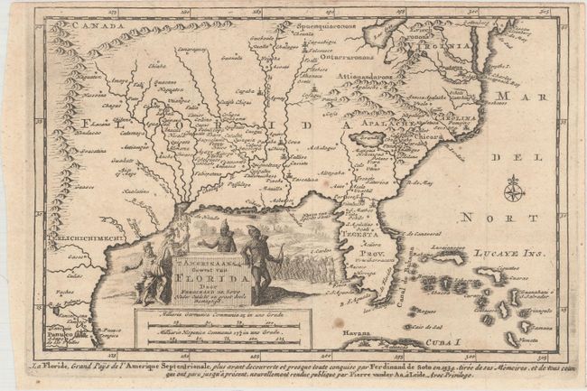
This interesting copper engraved map depicts the area explored by Hernando (or Ferdinand) de Soto and is based on Sanson's map of 1657. It covers the region from Texas to Chesapeake Bay, with many place names noted. The British colonies of Carolina and Virginia are shown east of the Appalachian Mountains, with the rest of the western part of the map named Florida. Lac Erie is shown considerably south of its actual location and the river systems are incorrect. A spurious north-south mountain range stretches through the central plains. Texas is labeled Terlichichimechi and the Florida Peninsula is named Tegesta Prov. A large title cartouche takes up the Gulf of Mexico with a scene of Hernando de Soto discussing his expedition with a group of Native Americans. De Soto landed in Florida in 1539, traveling throughout the South searching for gold and claiming land for Spain, until his death on the western banks of the Mississippi River in 1542.
References: Cumming (SE) #142; Tooley (MCC-68) #24.
Condition: B+
Issued folding on watermarked paper with a couple of spots of foxing and a narrow top margin, as issued.