Subject: Colonial Eastern North America
Period: 1702 (dated)
Publication: Atlas Curieux ou le Monde…
Color: Black & White
Size:
13.5 x 9.2 inches
34.3 x 23.4 cm
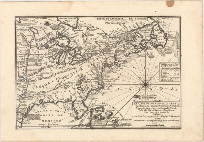
This small map of Eastern North America shows French and English territorial claims from the French perspective. It spans from the southern part of Hudson Bay to Havana, Cuba. The British colonies are squeezed along the Atlantic seaboard, while France controls the entire interior. The Mississippi Valley is well delineated and there are numerous notes, locations of forts, and Indian names. De la Salle's discovery of the mouth of the Mississippi (also referred to here as the Colbert River) is commemorated with a note. The Florida peninsula appears in an odd, nearly diamond-like shape with the water between it and the West Indies referred to as Detroit , ou Canal de Bahama. The Great Lakes are all connected here and have unusual or alternate names: Lake Superior is also called [Lac] du Tracy; Lake Michigan is Lac des Illinois; Lake Huron appears as Baye des Hurons; Lake Erie is instead Lac Frie; and Lake Ontario goes by Lac de Frontenac as well. Simple title cartouche with compass rose and rhumb lines in Atlantic finish the composition. The map was engraved by Herman van Loon, a skilled engraved who worked for several important cartographers including Delisle and Nolin.
References: Karpinski, p. 124, pl. 9; Pastoureau, FER I [110].
Condition: A
A dark impression on a clean sheet of watermarked paper with a few faint spots and minor staining confined to the top blank margin.