Subject: Northwestern Africa
Period: 1618 (published)
Publication: Theatrum Geographiae Veteris...
Color: Hand Color
Size:
18.2 x 12.7 inches
46.2 x 32.3 cm
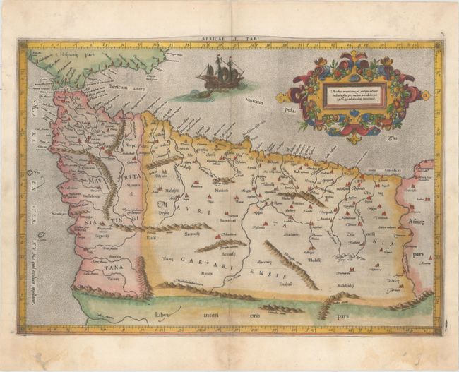
Claudius Ptolemy was a mathematician, astronomer and geographer who worked in Alexandria, then a part of the Roman Empire, in the 2nd century AD. One of the most learned and influential men of his time, his theories dominated both astronomy and geography for nearly 1500 years. His writings were kept alive by Arabic scholars during the Middle Ages and reemerged in Europe during the Renaissance. The birth of printing led to wide dissemination of his great works on astronomy and geography. There were a number of editions of his Geographia beginning in 1477. These early editions contained maps based on his original writings, known as Ptolemaic maps. As geographic knowledge increased with the explorations of Columbus, Magellan, Cabot and others, maps of the New World were added, and maps of the Old World were revised. Ptolemy's Geographia continued to be revised and published by some of the most important cartographers including Martin Waldseemuller, Sebastian Munster, Giacomo Gastaldi, Jodocus Hondius, and Gerard Mercator (whose last edition was published in 1730).
Lovely Ptolemaic map of the northwestern part of Africa, filled with ancient names, including the Straits of Gibraltar, here called the Herculeu fretum. Although he is most renowned today for his map projection and the popularization of the term "atlas" for a collection of maps, Gerard Mercator devoted much of his life to his Ptolemaic maps. The maps were beautifully engraved as nearly as possible to their original form from Ptolemy's textual descriptions and embellished with fine cartouches and scenes. This map is decorated with a lovely strapwork cartouche festooned with garlands of fruit and the stipple engraved sea includes a scene of a sea monster and sailing ship. Latin text on verso.
References: Mickwitz & Miekkavaara #232-12; Norwich #294; Van der Krogt (Vol. I) #0911:1.1.
Condition: B+
On watermarked paper with minor soiling, printer's ink residue, very light show through of text on verso, and professional repairs to a few chips and holes in bottom blank margin, not affecting map.