Subject: France
Period: 1535 (published)
Publication: Claudii Ptolemaei Alexandrini Geographicae…
Color: Hand Color
Size:
14.5 x 12.2 inches
36.8 x 31 cm
Claudius Ptolemy was a mathematician, astronomer and geographer who worked in Alexandria, then a part of the Roman Empire, in the 2nd century AD. One of the most learned and influential men of his time, his theories dominated both astronomy and geography for nearly 1500 years. His writings were kept alive by Arabic scholars during the Middle Ages and reemerged in Europe during the Renaissance. The birth of printing led to wide dissemination of his great works on astronomy and geography. There were a number of editions of his Geographia beginning in 1477. These early editions contained maps based on his original writings, known as Ptolemaic maps. As geographic knowledge increased with the explorations of Columbus, Magellan, Cabot and others, maps of the New World were added, and maps of the Old World were revised. Ptolemy's Geographia continued to be revised and published by some of the most important cartographers including Martin Waldseemuller, Sebastian Munster, Giacomo Gastaldi, Jodocus Hondius, and Gerard Mercator (whose last edition was published in 1730).
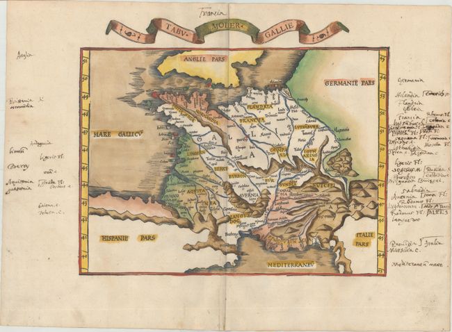
This Ptolemaic map is centered on France, and extends to include present-day Belgium, the Netherlands, Luxembourg, Switzerland, and parts of Germany and Italy. Exaggerated mountain ranges and ancient place names fill the map. A banner title appears above the neatline. Blank verso.
This map is from the atlas often referred to as 'editio prima Serveti' after its editor, Michael Villanovus, better known as Servetus, who was burned alive in 1553 for heresy. The map of the Holy Land from this atlas had on its verso a comment suggesting that the area was not as beautiful and fertile as generally believed, but was actually barren, according to travelers. This statement was one of the pieces of evidence used against Servetus. Calvin had many copies of the 1535 atlas confiscated and burned with Servetus.
References: Mickwitz & Miekkavaara #209-10.
Condition: B+
A nice impression with light soiling and numerous old manuscript notations in the blank margins.