Subject: Gulf of Mexico & Caribbean
Period: 1780 (dated)
Publication:
Color: Hand Color
Size:
36.7 x 19.4 inches
93.2 x 49.3 cm
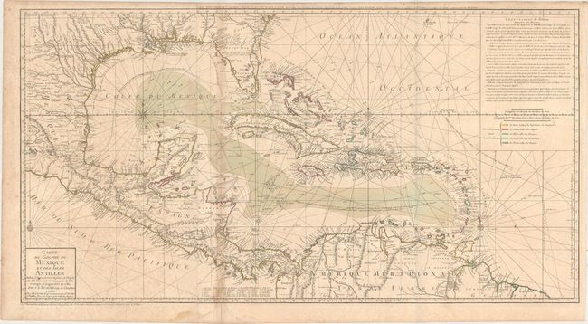
This uncommon map is focused on the Gulf of Mexico and includes the Caribbean Islands, Central America, and the northern tip of South America. The map is an updated version of Buache's map of 1740, which was based on Henry Popple's important and influential 21-sheet map of 1733. The map shows the variations in the trade winds and includes several navigation routes including the Spanish gold fleet from Vera Cruz to Havana. The entire coastal and interior areas are shown in excellent detail, particularly those of Florida and present-day Texas. The colonial possessions of the region are shown via a color-coded key at right, beneath a block of explanatory French text. The map is printed on two joined sheets, and is topped with a second title above the neatline; Carte d'une Partie de l'Amerique pour la Navigation...
References: Sellers & Van Ee #1707; Tooley (Amer) p. 29, #92.
Condition: B
Issued folding on watermarked paper with original color. There is a damp stain in the bottom blank margin and light toning along the left-hand fold; the slight bluish line along the right-hand fold is caused by our scanner and doesn't appear on the map itself. There are a couple of small holes along the left-hand fold, and the left-hand sheet has moderate foxing.