Catalog Archive
Auction 162, Lot 246

"Map of the State of Florida Showing the Progress of the Surveys Accompanying Annual Report of the Surveyor General for 1857", U.S. State Surveys
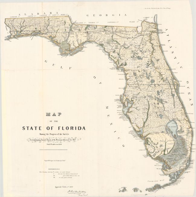
Subject: Florida

Period: 1857 (dated)

Publication: Senate Doc. No. 11 & HR Doc. No. 2, 35th Congress, 1st Session

Color: Hand Color

Size:
23.9 x 22.9 inches
60.7 x 58.2 cm
Download High Resolution Image
(or just click on image to launch the Zoom viewer)

An early state survey map drawn on a scale of 18 miles to the inch. It shows the topography, vegetation, towns, cities, forts, rivers, lakes, swamps and many early trails and roads. Most of the state is shown as surveyed. Area extends to show the keys and to Dry Tortugas Island and Ft. Jefferson, and locates Ft. Lauderdale, Boca Rabones, Key Biscayne, scores of keys and much, much more. It is signed in the plate by John Westcott, Surveyor General.

References:

Condition: B+

A very clean and bright example, issued folding, now flattened and backed in thin archival tissue to repair an 8" tear that extends into the title and separations along the folds, with minor loss of image in the far panhandle. The right margin is trimmed with minor loss of text.

Estimate: $200 - $230

Sold for: $150

Closed on 4/26/2017

Archived