Subject: Southwestern United States
Period: 1847 (circa)
Publication: HR Doc 41, 30th Congress, 1st Sess.
Color: Black & White
Size:
23 x 11.75 inches
58.4 x 29.8 cm
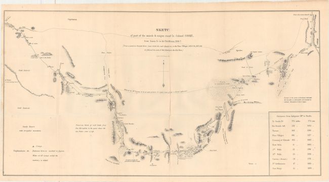
In 1846, when Stephen W. Kearny led the Army of the West in the conquest of New Mexico and California he was accompanied by officers of the Corps of Topographical Engineers. Lt. W.H. Emory followed Kearny across the desert and produced the expedition's main map. Lt. Col. Phillip, Lt. George Cooke and the "Mormon Battalion" took a more southerly route through the Guadeloupe Mountains and Tucson and produced this modest but important map. It records only the country actually seen; the exception being a dotted line inscribed "Believed by M. Leoux to be an open prairie good route if water is found sufficient." Antoine Leroux was a famed mountain man who was acting as guide for the expedition, but he was wrong about that alternate route. Wheat finds this to be a "magnificent achievement" drawing public attention to a stretch of territory deemed essential for a wagon and rail route that was later included in the Gadsden Purchase. The map terminates at the Pima Villages on the Gila (near present day Phoenix) where he picked up Kearney's trail.
References: Wheat (TMW) #505.
Condition: B+
A nice example, issued folding, with a few minor extraneous creases and pleasant light toning.