Subject: New Zealand
Period: 1773 (dated)
Publication: Voyage dans l'Hemisphere Australe, et Autour du Monde...
Color: Hand Color
Size:
14.8 x 7.9 inches
37.6 x 20.1 cm
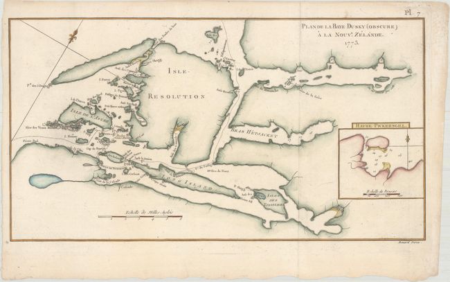
Captain James Cook (1728-1779) is best known for his three voyages to the Pacific (1768-71; 1772-75; and 1776-79). His discoveries radically changed the western understanding of the world in the late 18th century. He was the first to circumnavigate and chart New Zealand and provided the earliest European accounts of exploration along the eastern coast of Australia and the Hawaiian Islands. On February 14th, 1779, he was killed on Hawaii after attempting to kidnap the chief of the island.
Many contemporary accounts of Cook’s voyages, including charts and engravings, appeared in the late 18th century. The first official account of Cook’s first voyage was published in 1773 by John Hawkesworth in Volumes II and III of An Account of the Voyages Undertaken by the Order of His Present Majesty for Making Discoveries in the Southern Hemisphere... William Strahan and Thomas Cadell published the first official accounts of the second and third voyages in 1777 and 1784. Accounts of his exploration were subsequently translated into French, German, and Dutch.
A remarkable and early chart of the area centered on Resolution Island in today's Fiordland National Park on the southern island. The complex geography of the fiords is illustrated, naming Long Island, Point Five Fingers, Break-Sea Island, Gilbert Isles, Wetjacket Arm, Coopers Island, and much more. Inset details Pickersgill Harbour with a fleur-de-lis and soundings in fathoms. Engraved by Benard.
References: Shirley (BL Atlases) G.COOK-3a #3.
Condition: A
Issued folding, now flattened on watermarked paper with minor toning along the edges of the sheet.