Subject: Southern & Southeast Asia
Period: 1579 (published)
Publication: Theatrum Orbis Terrarum
Color: Hand Color
Size:
19.6 x 13.6 inches
49.8 x 34.5 cm
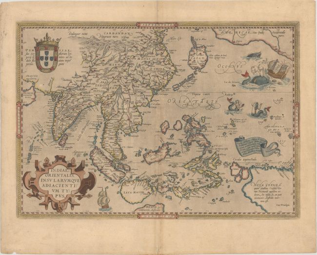
Ortelius' important map of Southeast Asia, based on Mercator's 1569 World map, shows how sketchy the available information was concerning the region. The East Indies are presented as a randomly scattered archipelago with Java and Borneo particularly misshapen. Taiwan is mapped for the first time as I. Fermosa in the 'tail' of kite-shaped Japan's Lequaio islands. The fictitious Chyamai lacus is the source of a network of major rivers in Southeast Asia. Beach pars, a presumed promontory of the great southern continent based on Marco Polo's account, protrudes into the bottom of the map. In the upper right corner, America makes an appearance with the three coastal cities of Quivira, Cicuie, and Tiguex. Near the shore lies a ship being menaced by a pair of sea monsters, while twin mermaids preen before each other near the Ladrone Islands. This is the first state with Latin text on verso.
References: Van den Broecke #166; Suarez, pp 164-69.
Condition: B+
The paper is lightly toned with Ortelius' common crossed arrows watermark. There is marginal soiling and a small worm track in bottom blank margin along the centerfold.