Subject: North Pole
Period: 1680 (circa)
Publication:
Color: Hand Color
Size:
20.6 x 16.1 inches
52.3 x 40.9 cm
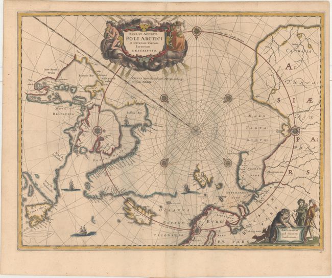
This beautiful map, originally published in 1637, eventually replaced Hondius' map of the North Pole and became the prototype for many later maps including those of Blaeu. This map incorporates the discoveries made by Captain Thomas James along the southern and western shores of Hudson Bay in 1631-2. The delineation on Russia's Arctic coast is derived from the information from Willem Barents' exploration of 1596-7. A small island off the coast of Lapland is named for the English explorer Hugh Willoughby (Sr. Hugo Willoughby's Landt), who led a failed expedition to find a Northeast Passage in 1553. Rhumb lines radiate from the North Pole, and several compass roses embellish the chart. A large title cartouche, with two figures and numerous wind heads, conveniently hides the northwest coast of America. The map is further decorated with ships and a cartouche with Jansson’s imprint, which depicts men in parkas, a polar bear, and foxes. This is the second state of the map with a legend beneath the cartouche. Blank verso.
References: Burden #250; cf. Kershaw #108a; Van der Krogt (Vol. I) #0020:1C:1:404/5 .
Condition: B+
Printed on double-thick paper, apparently as issued, with light toning and soiling. There are some bluish shadows to the right of the centerfold that are caused our scanner due to some minor cockling of the paper, and do not appear on the map itself.