Subject: Western United States & Mexico
Period: 1855 (circa)
Publication: Personal Narrative of Explorations…
Color: Black & White
Size:
19.4 x 15.2 inches
49.3 x 38.6 cm
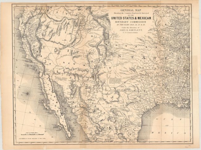
This map covers the entire western United States and northern Mexico with particular emphasis on the land recently obtained from Mexico. It is filled with place names, numerous Indian villages, geographical notes, and exploration routes. Wheat notes this is, all in all, an excellent map of the West that has a very early depiction of the Gadsden Purchase. It is one of the first commercial maps to show Jackson Lake east of the three Tetons. Sublettes Lake is noted as the source of the Yellowstone River. The geography of the unnamed Great Basin follows closely the cartography of Fremont's maps of 1845 and 1848. Utah is in its largest configuration stretching from California beyond the Continental Divide to Kansas. A note in the Staked Plains declares that "the whole country from the head waters of the Red, Brazos & Colorado Rivers to the Rio Pecos is a sterile and barren plain without water or timber producing only a few stinted shrubs which are insufficient to sustain animal life." Published by J.H. Colton & Co.
References: Wheat (TMW) #798; Wagner-Camp #234:1.
Condition: B
Issued folding and now flattened and backed with tissue to reinforce and repairs several small fold separations and a 1.5" binding tear at right. There are several light stains from old tape repairs on verso that have since been removed. A chip in the top right corner of the sheet including a small amount of image has been archivally reattached.