Subject: Louisiana
Period: 1761 (published)
Publication: London Magazine
Color: Hand Color
Size:
9.4 x 7.1 inches
23.9 x 18 cm
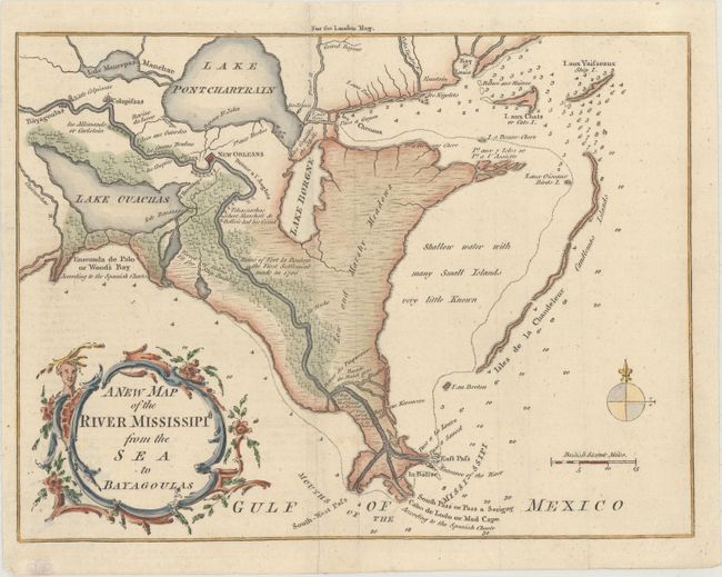
This is an uncommon map of the Mississippi Delta with great detail of the river and nearby settlements. This plan is taken from Thomas Jefferys' three-part map of the vicinity of New Orleans, which was derived directly from D'Anville's Carte de la Louisiane... drawn in 1732 and published in 1752. Though there is no engraver's signature, this map has been attributed to Thomas Kitchin, and certainly exhibits his engraving style. The map shows the course of the Mississippi from Bayagoulas and Little Colpissao (near the present-day town of Bayou Goula) to Fort la Balise, which defends the entrance and channel of the river. An important feature of this map is the depiction of the Ruins of Fort La Boulaye the First Settlement made in 1700. This fort, located on the eastern bank of the Mississippi River about fifty miles from the Gulf of Mexico, was established by Pierre Le Moyne d'Iberville in 1700 and was abandoned about seven years later. In 1933 the remains of Fort La Boulaye were discovered near present-day Phoenix, Louisiana, in Plaquemines Parish. The map is adorned with a large rococo-style title cartouche and small compass rose.
References: Jolly #LOND-198.
Condition: A
Issued folding, now flattened with a small stain at bottom left, well outside of image.