Subject: Hawaii
Period: 1786 (circa)
Publication: Atlas du Voyage de la Perouse...
Color: Black & White
Size:
19.4 x 26.8 inches
49.3 x 68.1 cm
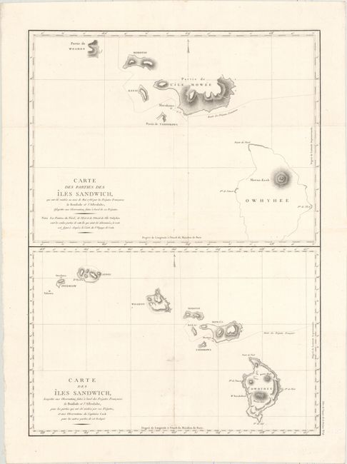
Jean-Francois de Galoup, Comte de La Perouse commanded a French scientific expedition to the Pacific in 1785-88. Recognized as one the foremost naval commanders and navigators in France, he was selected by King Louis XVI to complete Captain James Cook's exploration of the western Pacific. The British Admiralty provided scientific equipment to measure variations in magnetic compass readings and with the latest instruments for determining longitude. La Perouse explored the coasts of the Gulf of Alaska and northwestern North America in search of the fabled Northwest Passage. After leaving America his expedition continued on to Asia where he explored from Macao to Kamchatka and the Solomon Islands in the South Pacific. La Perouse was meticulous in sending copies of his extensive logs, maps and surveying information via other ships as well as overland. La Perouse's last contact was in the spring of 1788 with a British ship in Botany Bay, Australia. The expedition was never heard from again. Considered one of the greatest French voyages, the French Government decided to publish the story of the expedition when it became clear they had been lost. An English edition was published in London.
This large double-page folio sheet contains two important charts of Hawaii based on the discoveries of Capt. Cook and La Perouse. The top chart shows partial coastlines of Hawaii, Maui, Molokai, and Oahu as explored in 1786. The bottom chart shows the same islands as discovered on Captain Cook’s third voyage and details La Perouse’s route through the islands. It depicts all of the islands from Niihau in the northwest to Hawaii in the east. On the chart Hawaii is called Owhyhee, Oahu is Woahoo, Molokai is Morotoi, and Niihau is Oneeheow. Published in Atlas du Voyage de la Perouse... from 1786-97.
References:
Condition: B+
A fine impression on a watermarked sheet with a fold separation in the lower map that has been closed on verso with archival material. Light surface soiling.